
Hydrologic Monitoring Branch
Applied Hydrology Branch
Hydrologic Interpretive Branch
Stay in-the-know with New England Water Science Center’s WaterMarks Newsletter
New England Water Science Center
Welcome to the USGS New England Water Science Center. We provide timely and reliable information to Federal, State, Tribal, and local stakeholders on the water resources of Connecticut, Maine, Massachusetts, New Hampshire, Rhode Island, and Vermont. Our data help safeguard human and wildlife health, public safety, and environmental sustainability.
For assistance, contact us on our Connect page.

News
USGS Launches Interactive Streamflow Map Tools
USGS Launches Interactive Streamflow Map Tools
USGS Scientists at the 2026 Long Island Sound Research Conference
USGS Scientists at the 2026 Long Island Sound Research Conference
WaterMarks Newsletter - Summer 2026
WaterMarks Newsletter - Summer 2026
Publications
An automatable method for developing preliminary stream crossing designs using lidar and hydraulic modeling in Massachusetts An automatable method for developing preliminary stream crossing designs using lidar and hydraulic modeling in Massachusetts
Upgrading aging and undersized stream crossings (places where culverts and bridges intersect a stream) with replacements designed for aquatic organism passage can improve infrastructure resiliency, geomorphic stability, and maintenance costs. The goal of this work is to develop preliminary culvert designs that convey hydraulic design floods and meet the Massachusetts Stream Crossings...
Predictions of anthropogenic background PFAS concentrations in soil and relation to bedrock lithology and groundwater quality Predictions of anthropogenic background PFAS concentrations in soil and relation to bedrock lithology and groundwater quality
Detectable concentrations of per- and polyfluoroalkyl substances (PFAS) have been observed in soils in remote areas and presumably originate from atmospheric deposition. These anthropogenic background concentrations may enable some PFAS to leach to groundwater at levels that exceed regulatory criteria for drinking water. However, anthropogenic background soil concentrations and their...
Simulation of groundwater flow to evaluate hydrogeologic controls on a PFAS plume, Coakley Landfill Superfund site, Rockingham County, New Hampshire Simulation of groundwater flow to evaluate hydrogeologic controls on a PFAS plume, Coakley Landfill Superfund site, Rockingham County, New Hampshire
Per- and polyfluoroalkyl substances (PFAS), including perfluorooctanoic acid (PFOA) and perfluorooctanesulfonic acid (PFOS), have been detected at combined concentrations above 2,000 nanograms per liter (ng/L) at groundwater seep locations near the Coakley Landfill Superfund site, in North Hampton, New Hampshire. The landfill was active from 1972 to 1985. An impermeable cap was placed on...
Science
Assessing Sustainable Water Use in Connecticut
The U.S. Geological Survey (USGS) New England Water Science Center, in cooperation with the Connecticut Department of Energy and Environmental Protection (CT DEEP), is updating a planning-level support tool to help decision makers estimate daily mean streamflows and selected streamflow statistics to assess sustainable water use across the state of Connecticut.
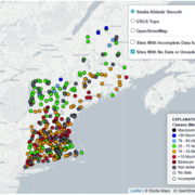
New England Water Conditions Explorer
The New England Water Conditions Explorer provides interactive maps showing current surface water and groundwater conditions in the context of historical data.
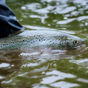
Thermal Imaging to Detect Cold-Water Habitat for Atlantic Salmon and Brook Trout at Katahdin Woods and Waters National Monument
The U.S. Geological Survey (USGS), in cooperation with the National Park Service (NPS), is using airborne thermal infrared remote sensing to characterize cold-water habitat for the federally designated endangered species Atlantic salmon ( Salmo salar) and wild brook trout ( Salvelinus fontinalis) in the East Branch of the Penobscot River system within Katahdin Woods and Waters National Monument...