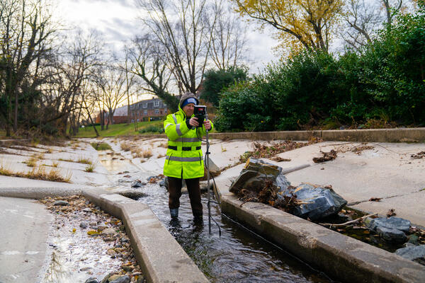
Hydrologic technician Mike Geissel obtains a streamflow measurement at West Branch Herring Run at Idlewylde, MD, USGS-01585200.
Fall 2025 Photo Contest Winner: David Fisher, Honorable Mention category.

Official websites use .gov
A .gov website belongs to an official government organization in the United States.
Secure .gov websites use HTTPS
A lock () or https:// means you’ve safely connected to the .gov website. Share sensitive information only on official, secure websites.
Michael Geissel is a Hydrologic Technician for the U.S. Geological Survey, currently working at the MD-DE-DC Water Science Center in the Baltimore office.

Hydrologic technician Mike Geissel obtains a streamflow measurement at West Branch Herring Run at Idlewylde, MD, USGS-01585200.
Fall 2025 Photo Contest Winner: David Fisher, Honorable Mention category.
Hydrologic technician Mike Geissel obtains a streamflow measurement at West Branch Herring Run at Idlewylde, MD, USGS-01585200.
Fall 2025 Photo Contest Winner: David Fisher, Honorable Mention category.

A video detailing the roles and responsibilities of the USGS's Maryland-Delaware-D.C., Baltimore Surface Water team.
A video detailing the roles and responsibilities of the USGS's Maryland-Delaware-D.C., Baltimore Surface Water team.
")
A video detailing the roles and responsibilities of the USGS's Maryland-Delaware-D.C., Baltimore Surface Water team.
A video detailing the roles and responsibilities of the USGS's Maryland-Delaware-D.C., Baltimore Surface Water team.

When a major storm is forecasted to affect the Delmarva region, up-to-date information is vital for the response.
That’s when USGS crews spring into action, setting up rapid deployment gages that provide additional surge, wave, and tide hydrodynamics (SWaTH) data that augments our existing streamgage network.
")
When a major storm is forecasted to affect the Delmarva region, up-to-date information is vital for the response.
That’s when USGS crews spring into action, setting up rapid deployment gages that provide additional surge, wave, and tide hydrodynamics (SWaTH) data that augments our existing streamgage network.
")
When a major storm is forecasted to affect the Delmarva region, up-to-date information is vital for the response.
That’s when USGS crews spring into action, setting up rapid deployment gages that provide additional surge, wave, and tide hydrodynamics (SWaTH) data that augments our existing streamgage network.
When a major storm is forecasted to affect the Delmarva region, up-to-date information is vital for the response.
That’s when USGS crews spring into action, setting up rapid deployment gages that provide additional surge, wave, and tide hydrodynamics (SWaTH) data that augments our existing streamgage network.
")
What is HIVIS?
HIVIS stands for Hydrologic Imagery Visualization and Information System.
HIVIS is a network of cameras across the United States that serve as remote “eyes on the ground,” providing the USGS and its cooperators with the ability to monitor conditions in near real-time at sites where a camera is installed.
Hydrologic technician Mike Geissel obtains a streamflow measurement at West Branch Herring Run at Idlewylde, MD, USGS-01585200.
Fall 2025 Photo Contest Winner: David Fisher, Honorable Mention category.
Hydrologic technician Mike Geissel obtains a streamflow measurement at West Branch Herring Run at Idlewylde, MD, USGS-01585200.
Fall 2025 Photo Contest Winner: David Fisher, Honorable Mention category.
A video detailing the roles and responsibilities of the USGS's Maryland-Delaware-D.C., Baltimore Surface Water team.
A video detailing the roles and responsibilities of the USGS's Maryland-Delaware-D.C., Baltimore Surface Water team.
A video detailing the roles and responsibilities of the USGS's Maryland-Delaware-D.C., Baltimore Surface Water team.
A video detailing the roles and responsibilities of the USGS's Maryland-Delaware-D.C., Baltimore Surface Water team.
When a major storm is forecasted to affect the Delmarva region, up-to-date information is vital for the response.
That’s when USGS crews spring into action, setting up rapid deployment gages that provide additional surge, wave, and tide hydrodynamics (SWaTH) data that augments our existing streamgage network.
What is HIVIS?
HIVIS stands for Hydrologic Imagery Visualization and Information System.
HIVIS is a network of cameras across the United States that serve as remote “eyes on the ground,” providing the USGS and its cooperators with the ability to monitor conditions in near real-time at sites where a camera is installed.
*Disclaimer: Listing outside positions with professional scientific organizations on this Staff Profile are for informational purposes only and do not constitute an endorsement of those professional scientific organizations or their activities by the USGS, Department of the Interior, or U.S. Government