
5 maps of dates of land-use and land-cover data
By Western Geographic Science Center
2001 (approx.)

Detailed Description
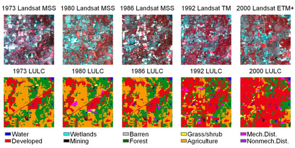
An example of the 5 dates of land-use and land-cover data available for each sample block. The data shown here is for sample 74_0134 in the Mississippi Valley Loess Plains ecoregion, located on the northeastern edge of Memphis, Tennessee. Note-the Landsat imagery are not available for download as part of this paper.
Sources/Usage
Related

Land Cover Trends
Land Cover Trends was a research project focused on understanding the rates, trends, causes, and consequences of contemporary U.S. land use and land cover change. The project spanned from 1999 to 2011. The research was supported by the Climate and Land Use Change Research and Development Program of the U.S. Geological Survey (USGS) and was a collaborative effort with the U.S. Environmental...
Related
Land Cover Trends
Land Cover Trends was a research project focused on understanding the rates, trends, causes, and consequences of contemporary U.S. land use and land cover change. The project spanned from 1999 to 2011. The research was supported by the Climate and Land Use Change Research and Development Program of the U.S. Geological Survey (USGS) and was a collaborative effort with the U.S. Environmental...