
WGSC contributes to HayWired
The GFSAD30 project accomplished their goal!
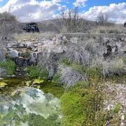
Dryland Management
Aridland Water Harvesting
Cienega Ranch
Semi-desert Native Grassland Restoration
Western Geographic Science Center
The WGSC is responsible for research and applications to understand coupled human-environmental systems in the face of land change and delivering pertinent information to decision makers on the vulnerability and resilience of these systems. WGSC scientists collaborate with partners to advance the goals of the USGS Core Science Systems and Ecosystems Mission Areas and their programs.
Dr. Prasad Thenkabail visits India in Scientist Exchange Program

Congratulations to Dr. Prasad Thenkabail, Research Geographer at WGSC, who represented the Department of Interior at the NASA and Indian Space Research Organization Professional Engineer and Scientist Exchange Program. Congratulations Prasad!
Dr Laura Norman wins the Farouk El-Baz Award

Congratulations to Dr. Laura Norman, who won the Farouk El-Bak Award for desert research!
Projects and teams at WGSC
Just a few examples of WGSC projects and science teams.
- Hazards Vulnerability Team
- Global Food Security-Support Analysis Data at 30 m (GFSAD30)
- Hazards Societal Consequences and Risk Communication
- Land-Use and Climate Change Team (LUCC)
- Aridlands Water Harvest Study
- Applied Landscape Ecology and Remote Sensing
- Patterns in the Landscape – Analyses of Cause and Effect (PLACE)
News
Dr. Pardhasaradhi Teluguntla receives ESRI's Award for Best Scientific Paper in GIS -1st Place
Earth Science Matters - Vol. 21 | Issue 1
WGSC cloud-based tidal marsh biomass mapping tool
Publications
Comparing DESIS hyperspectral and Landsat 10 simulated superspectral data for crop type classification in California's Central Valley Comparing DESIS hyperspectral and Landsat 10 simulated superspectral data for crop type classification in California's Central Valley
Los Planes watershed vegetation monitoring: Standard operating procedures Los Planes watershed vegetation monitoring: Standard operating procedures
Initial condition uncertainty exerts a large and persistent influence on model simulations of ecosystem carbon dynamics in California Initial condition uncertainty exerts a large and persistent influence on model simulations of ecosystem carbon dynamics in California
Science

New Tools for Modern Land Management Decisions
Las Moras Wash Restoration: Integrated Geomorphic Assessment, Modeling, Monitoring, and Adaptive Management
