
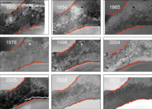
Aerial imagery sequence of Indian Point, Louisiana, 1950–2012
By St. Petersburg Coastal and Marine Science Center
2012 (approx.)

Detailed Description
Aerial imagery sequence of Indian Point, Louisiana, showing the contraction of the peninsula marsh in response to shoreline erosion since 1950.
Sources/Usage
Public Domain.
Related

Gulf Coast Wetland Shoreline Change
Land and seafloor slopes are generally low along the coasts in the Mid-Atlantic and Gulf Coast states, making wetlands and estuaries vulnerable to sea level change, subsidence, and extreme events (e.g., hurricanes and tropical storms). Land-use change and land loss have been mapped extensively and with increasing frequency, but the link between land loss and the processes responsible for landscape...
Related
Gulf Coast Wetland Shoreline Change
Land and seafloor slopes are generally low along the coasts in the Mid-Atlantic and Gulf Coast states, making wetlands and estuaries vulnerable to sea level change, subsidence, and extreme events (e.g., hurricanes and tropical storms). Land-use change and land loss have been mapped extensively and with increasing frequency, but the link between land loss and the processes responsible for landscape...