
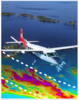
Airplane Conducting Geophysical Survey Illustration
By Geology, Geophysics, and Geochemistry Science Center
2013 (approx.)

Detailed Description
Graphic of airplane in flight conducting an airborne geophysical survey with flight lines and resulting geophysical data.
Sources/Usage
Public Domain.
Related

Airborne Geophysics for Rare Earth Element Deposits (AGREED)
The USGS Airborne Geophysics for Rare Earth Element Deposits (AGREED) project coordinated with industry to use high resolution airborne geophysical data collected over some of the advanced rare earth element (REE) projects in the U.S. These data were analyzed, interpreted and modeled to generate an improved understanding of the geologic setting, framework, and ore genesis for REE deposits. In...
Related
Airborne Geophysics for Rare Earth Element Deposits (AGREED)
The USGS Airborne Geophysics for Rare Earth Element Deposits (AGREED) project coordinated with industry to use high resolution airborne geophysical data collected over some of the advanced rare earth element (REE) projects in the U.S. These data were analyzed, interpreted and modeled to generate an improved understanding of the geologic setting, framework, and ore genesis for REE deposits. In...