
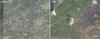
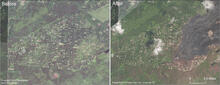
Before and after satellite images of Leilani Estates subdivision

Detailed Description
This comparison shows satellite images of Leilani Estates subdivision before and after the May-August 2018 eruption. The image on the right, collected in early September 2018, shows that the eastern portion of the subdivision has been covered by lava. The Fissure 8 lava channel runs northeast, with the Fissure 8 cone at the start of the channel. Note also the brown areas (dead vegetation) south of the flow. Highway 130 runs north-south along the left side of the images.
Sources/Usage
Public Domain.