
April 2025 Flooding in the US

Detailed Description
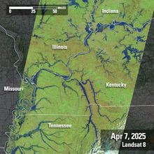
Powerful storms containing heavy rains caused major flooding to areas in the east central portion of the United States in early April 2025. Some communities in Kentucky saw more than 15 inches of rain, according to the National Weather Service. In the days following April 7th — the day Landsat 8 captured this imagery over a portion of the affected area, — the Kentucky and Ohio rivers were forecast to reach historic levels and crest in dozens of locations, before the surge of water moves into the Mississippi River, where flooding is also expected.
When compared to the image acquired on March 22th of the same area, it is easy to see that the vegetation quickly emerged from winter dormancy to seasonal springtime green hues. The exponential rains quickly filled rivers and streams, as is easy to see on the later image as well.
Landsat 8
Path 22 Row 34-35
April 7, 2025
Sources/Usage
Public Domain.