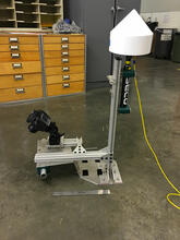
Camera rig and GPS receiver
By Pacific Coastal and Marine Science Center
2014 (approx.)
Detailed Description
Special camera rig and precision GPS receiver (right) designed to take Structure from Motion photos from a small airplane.
Sources/Usage
Public Domain.
Related Content
Remote Sensing Coastal Change
We use remote-sensing technologies—such as aerial photography, satellite imagery, structure-from-motion (SfM) photogrammetry, and lidar (laser-based surveying)—to measure coastal change along U.S. shorelines.
Related Content
Remote Sensing Coastal Change
We use remote-sensing technologies—such as aerial photography, satellite imagery, structure-from-motion (SfM) photogrammetry, and lidar (laser-based surveying)—to measure coastal change along U.S. shorelines.