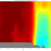
An official website of the United States government
Here's how you know
Official websites use .gov
A .gov website belongs to an official government organization in the United States.
Secure .gov websites use HTTPS
A lock () or https:// means you’ve safely connected to the .gov website. Share sensitive information only on official, secure websites.
Due to a lapse in appropriations, the majority of USGS websites may not be up to date and may not reflect current conditions. Websites displaying real-time data, such as Earthquake, Volcano, LANDSAT and Water information needed for public health and safety will be updated with limited support. Additionally, USGS will not be able to respond to inquiries until appropriations are enacted. For more information, please see www.doi.gov/shutdown.
Water-quality data are collected in Lake Koocanusa at the international boundary and on the Kootenai River downstream of Libby Dam. Water depth changes over the season and the platform records data from the water surface to the bottom of the lake, regardless of the lake's depth. Data in graphs are updated weekly to present the latest results. All data are considered provisional.
Lake Koocanusa Temperature and Specific Conductance Profiles
Water-quality data are collected in Lake Koocanusa at the international boundary and on the Kootenai River downstream of Libby Dam. Water depth changes over the season and the platform records data from the water surface to the bottom of the lake, regardless of the lake's depth. Data in graphs are updated weekly to present the latest results. All data are considered provisional.