
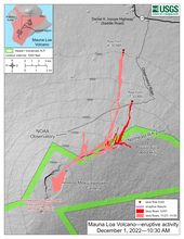
December 1, 2022 — Mauna Loa Eruption Map

Detailed Description
The Northeast Rift Zone eruption of Mauna Loa has continued into its fourth full day. At this time two fissures are active, sending lava flows primarily to the north-northeast. Webcam and satellite views overnight allowed USGS analysts to accurately map some of the most active flows, displayed in red here, along with older flows further uprift and in part of Mokuʻāweoweo Caldera. Elsewhere the progression of the flows is marked by points for the flow fronts, mapped by HVO field crews.
Sources/Usage
Public Domain.