U.S. flag

An official website of the United States government

December 1, 2022

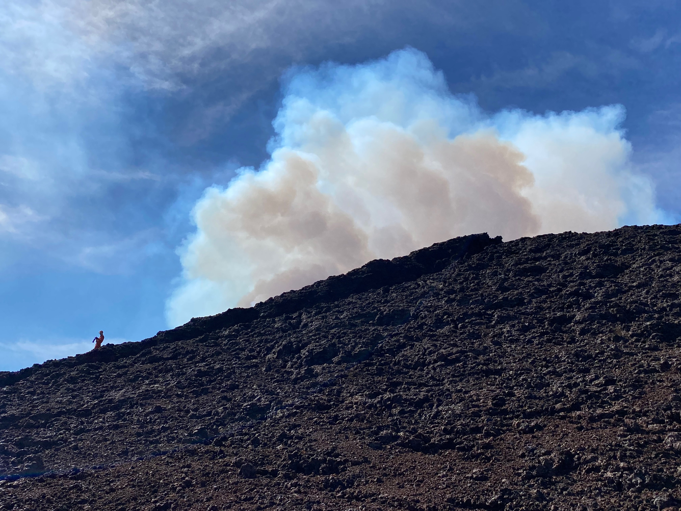
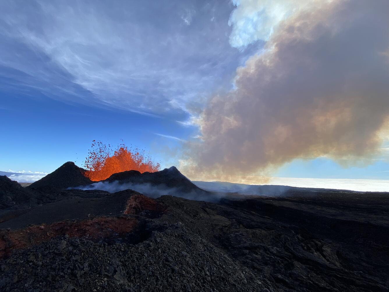
Mauna Loa's Northeast Rift Zone eruption continues. No property is at risk currently. There is a visible gas plume from the erupting fissure fountains and lava flows.

Mauna Loa update: https://www.usgs.gov/volcanoes/mauna-loa/volcano-updates

County of Hawaii Civil Defense Agency: https://hawaii-county-civil-defense-agency-hawaiicountygis.hub.arcgis.com/

Color photograph of lava channel
View of of the lava channel that exits from Fissure 3 and is flowing downhill  from the Northeast Rift Zone of Mauna Loa. Once a channel forms, the lava can stay insulated and more fluid as it flows. This can allow for lava to move fast in steep parts of its channel and create rapids. USGS image by D. Downs.
Color photograph of volcanic vent
Zoomed in aerial view of Fissure 3 erupting on the Northeast Rift Zone of Mauna Loa. Its lava fountains consistently throw molten lava bombs up to 30 m (98 ft) in the air with some bursts to 40 m (131 ft) high. Over time as these bombs cool, around the base of the fissure, they built up a spatter cone. Since Fissure 3 became the dominant source of lava effusion, it has built up a significant spatter cone around its lava fountains. USGS image by D. Downs.
Color photograph of eruption
Aerial view of Fissure 3 and its channel that is flowing downslope from the Northeast Rift Zone of Mauna Loa. The upper left side of the photo is Mauna Kea. Over the past 24 hours Fissure 3 has built up a significant spatter rampart around its lava fountains. The air is thick with a sulfur plume that is degassing from the lava as it rises to the surface here. USGS image by D. Downs.
Color photograph lava channel
Fissure 3 on Mauna Loa's Northeast Rift Zone has produced several lava channels that are winding their way down the northeast slopes of the volcano. These channels are surrounded by levees that insulate the lava and keep it fluid and moving at a brisk pace downslope. As it cools it can form a black crust on top of it in places. In this photo, the lava channels branch and rejoin each other to immediately branch again. USGS image by D. Downs.
Color photograph of volcanic vent
Aerial view of Fissure 3 erupting on the Northeast Rift Zone of Mauna Loa, and the channel that exits it to the left side of the photo. Over the past 24 hours, Fissure 3 has built up a significant spatter rampart around its lava fountains. The air is thick with a sulfur plume that is degassing from the lava as it rises to the surface here. USGS image by D. Downs.
bucket downwind of erupting lava
December 1, 2022 - USGS Hawaiian Volcano Observatory geologists deploy buckets downwind of the erupting fissures to collect samples. These samples will be analyzed to learn about lava being erupted by Mauna Loa's Northeast Rift Zone.
View of fissure 3 erupting on Mauna Loa's Northeast Rift Zone
View of fissure 3 erupting on Mauna Loa's Northeast Rift Zone. View is from approximately 500 meters downrift.
view of the eruption plume from fissure 3
December 1, 2022 - A view of the eruption plume from fissure 3 on Mauna Loa's Northeast Rift Zone. Geologist for scale on the left. USGS image by J. Schmith.
lava erupting from Fissure 3 on Mauna Loa
View of fissure 3 on Mauna Loa's Northeast Rift Zone erupting during the morning of December 1, 2022. Fissure 3 continues to be the dominant of two erupting fissures on Mauna Loa's Northeast Rift Zone.
Video of fissure 3 on Mauna Loa's Northeast Rift Zone erupting during the morning of December 1, 2022. Fissure 3 continues to be the dominant of two erupting fissures on Mauna Loa's Northeast Rift Zone.
Aerial footage of the Northeast Rift Zone eruption of Mauna Loa captured the morning of December 1, 2022.
Aerial footage of the Northeast Rift Zone eruption of Mauna Loa captured the morning of December 1, 2022. USGS video by M. Patrick.
Aerial footage of the Northeast Rift Zone eruption of Mauna Loa captured the morning of December 1, 2022.
Color map of eruption
The Northeast Rift Zone eruption of Mauna Loa has continued into its fourth full day. At this time two fissures are active, sending lava flows primarily to the north-northeast. Webcam and satellite views overnight allowed USGS analysts to accurately map some of the most active flows, displayed in red here, along with older flows further uprift and in part of Mokuʻāweoweo Caldera. Elsewhere the progression of the flows is marked by points for the flow fronts, mapped by HVO field crews.

Get Our News

These items are in the RSS feed format (Really Simple Syndication) based on categories such as topics, locations, and more. You can install and RSS reader browser extension, software, or use a third-party service to receive immediate news updates depending on the feed that you have added. If you click the feed links below, they may look strange because they are simply XML code. An RSS reader can easily read this code and push out a notification to you when something new is posted to our site.