
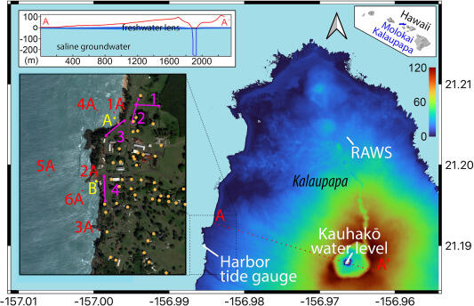
Figure shows Lidar (Light detection and ranging) elevation map of Kalaupapa, Moloka‘i, Hawai‘i
Detailed Description
Figure shows Lidar (Light detection and ranging) elevation map of Kalaupapa, Moloka‘i, Hawai‘i, including locations of instruments, sample, and ERT locations. Radon-222 sampling locations (A) and (B) in yellow coincide with freshwater spring locations, nutrient sample locations in red, ERT profiles in purple, cesspools in orange, and water level and tide gauge indicated for Kalaupapa Harbor and Kauhakō Crater lake. Rainfall was measured from the Remote Automatic Weather Station (RAWS). Profile A to A' from the Lidar map is shown as an insert in the upper left and includes the freshwater lens interpretation and bathymetric mapping of Kauhakō Crater lake.
Sources/Usage
Public Domain.