
Flood inundation map library

Detailed Description
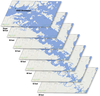
A flood inundation map library is a set of maps that show the spatial extent and depth of flooding at specific water-level (stream stage) intervals along an individual stream section. For example, one inundation map might be produced at every foot of stream stage along a typical flood hydrograph. These maps are created using hydraulic and topographic modeling and can more accurately visualize a wider range of flooding scenarios than relying on past experiences alone.
Sources/Usage
Public Domain.
Related

Flood Inundation Mapping Science
When planning for a flood, there are three key questions that must be answered: What areas will be flooded? How deep will the floodwaters get? When will the flood arrive? A flood inundation map library is a set of maps that together show where flooding may occur – and how deep it may be - over a range of potential flooding scenarios in a stream or river.
Related
Flood Inundation Mapping Science
When planning for a flood, there are three key questions that must be answered: What areas will be flooded? How deep will the floodwaters get? When will the flood arrive? A flood inundation map library is a set of maps that together show where flooding may occur – and how deep it may be - over a range of potential flooding scenarios in a stream or river.