
Graph of Halema‘uma‘u crater floor elevation over the past year, Kīlauea volcano
Detailed Description
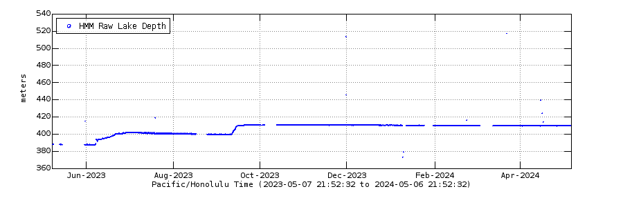
Graph showing the depth of lava (in meters) in Halema‘uma‘u crater, at Kīlauea volcano's summit, over the past year. A laser rangefinder stationed at Kīlauea volcano's summit continuously measures the distance to a location on the western lava lake surface, and telemeters data to HVO in real time. The raw data has been edited for this graph, with a running mean average filter of 3600 seconds. Variations in plotted depth can occur due to laser rangefinder returns on gas rather than the lava surface.
For reference, the base of Halema‘uma‘u after the 2018 collapse event is “zero” on this plot (equal to an elevation of 518 meters/1699 ft above sea level). Post-eruption analyses indicate that the December 2020–May 2021 lava lake filled the base of Halema‘uma‘u to a depth of 223 meters/732 ft (equal to an elevation of approximately 741 meters/2431 ft above sea level). The ongoing eruption is adding to that lava depth. Lava overflowed Halema‘uma‘u, onto the lowest down-dropped block when the eastern portion reached a depth of 267 meters/876 ft (equal to an elevation of 790 meters/2592 ft above sea level). See the Kīlauea daily updates for more information.
Sources/Usage
Public Domain.