
Landsat Collection 2 Digital Elevation Modeling (DEM) Sources

Detailed Description
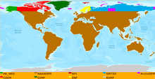
This map displays the Digital Elevation Modeling (DEM) sources used in Landsat Collection 2 Level-1 data processing.
Sources/Usage
Public Domain.
Related

USGS EROS Archive - Landsat Archives - Landsat Collection 2 Digital Elevation Model
Several digital elevation model sources are used in the processing of Landsat Collection 2 Level-1, Level-2, and Level-3 products. These sources, based on specific geographic regions, contribute to improved vertical accuracy in Collection 2 when compared to data processed in the past. Together, these sources are all known as the Landsat Collection 2 Digital Elevation Model (DEM).
Related
USGS EROS Archive - Landsat Archives - Landsat Collection 2 Digital Elevation Model
Several digital elevation model sources are used in the processing of Landsat Collection 2 Level-1, Level-2, and Level-3 products. These sources, based on specific geographic regions, contribute to improved vertical accuracy in Collection 2 when compared to data processed in the past. Together, these sources are all known as the Landsat Collection 2 Digital Elevation Model (DEM).