
Landsat Dashboard.png
By Landsat Missions
April 2022 (approx.)

Detailed Description
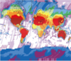
Image showing number of Landsat scenes available by location globally over 50 years. Can search by spacecraft identification, sensor identification, year acquired, processing level, and collection category. Maps are interactive and highlight spatial and temporal distribution of the Landsat archive.
Sources/Usage
Public Domain.