
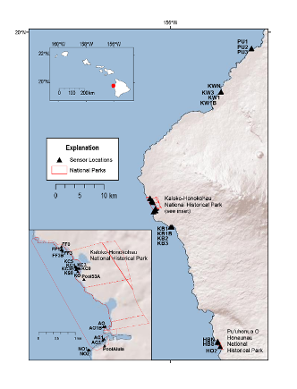
Location map of temperature time-series data, west Hawaii

Detailed Description
Location map of temperature time-series data collected along the coral reef coastline of west Hawaii Island (2010-2014).
Sources/Usage
Public Domain.
U.S. Geological Survey data release
Spatial and continuous time-series measurements of water properties, including temperature, salinity, pH, and dissolved oxygen, from a range of depths and distances from shore, were collected along the west coast of the Island of Hawaii. These data and associated analyses help characterize the variability of coral reef habitats, and in particular, the influence of low temperature and low salinity groundwater entering the nearshore on coral health.