
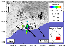
Map of Kīlauea showing the south-SE motion, as recorded by continuo...
By Hawaiian Volcano Observatory
2010 (approx.)

Detailed Description
Map of Kīlauea Volcano showing the south-southeast motion, as recorded by continuous GPS sites (arrows), and earthquake epicenter between February 1-3, 2010.
Sources/Usage
Public Domain.
Related

Deformation Monitoring Tracks Moving Magma and Faults
Ground deformation measurements provide an important indicator about what is happening beneath a volcano. As magma accumulates in an underground reservoir before an eruption, the ground surface typically swells (named inflation).
Related
Deformation Monitoring Tracks Moving Magma and Faults
Ground deformation measurements provide an important indicator about what is happening beneath a volcano. As magma accumulates in an underground reservoir before an eruption, the ground surface typically swells (named inflation).