
The camera view is east-southeast from the seismic/infrasound monitoring station in Biscuit Basin, Yellowstone National Park.
Michael Poland
Mike Poland is a research geophysicist with the Cascades Volcano Observatory and the current Scientist-in-Charge of the Yellowstone Volcano Observatory.
Mike's area of specialization is volcano geodesy, which emphasizes the surface deformation and gravity fields associated with volcanic activity. This work involves the use of space-based technologies, like Interferometric Synthetic Aperture Radar (InSAR), as well as ground-based techniques, like microgravity surveys. Mike has taken part in studies on a variety of volcanic systems in the United States, including Mount St. Helens and other volcanoes of the Pacific Northwest, Kilauea and Mauna Loa volcanoes in Hawaii, and the Yellowstone caldera. His recent work has focused on using gravity change over time to understand the character of the fluids that drive volcanic unrest, and also on the potential of satellite data to improve forecasts of future changes in volcanic activity.
Science and Products
Uplift along the north rim of Yellowstone Caldera
An area on the north rim of Yellowstone caldera, to the south of Norris Geyser Basin, started to uplift slightly in July 2025. Similar deformation occurred in the same area during 1996-2004 and reveals characteristics of the subsurface.

Optimizing satellite resources for the global assessment and mitigation of volcanic hazards
A vast number of the world’s volcanoes are unmonitored by ground-based sensors, yet constitute an important hazard to nearby residents and infrastructure, as well as air travel and the global economy. Satellite data provide a cost-effective means of tracking activity at such volcanoes. Unfortunately, satellite acquisitions are not optimized for application to volcano hazards, in part...
Filter Total Items: 172
Biscuit Basin webcam
The camera view is east-southeast from the seismic/infrasound monitoring station in Biscuit Basin, Yellowstone National Park.
")
Another hydrothermal explosion at Biscuit Basin (Yellowstone Monthly Update - June 2026)
Another hydrothermal explosion at Biscuit Basin (Yellowstone Monthly Update - June 2026)On June 13, 2026, Yellowstone National Park’s newest geophysical monitoring sites captured a small hydrothermal explosion in Biscuit Basin! That story is the subject of this month’s video update.

Water spouting on June 18, 2026, from a new thermal pool that formed shortly after a small hydrothermal explosion at Biscuit Basin, Yellowstone National Park, on June 13, 2026
Water spouting on June 18, 2026, from a new thermal pool that formed shortly after a small hydrothermal explosion at Biscuit Basin, Yellowstone National Park, on June 13, 2026This video is from the Biscuit Basin camera, which is located on the boardwalk adjacent to Black Diamond Pool (the blue-water feature in the foreground) and looking to the north. Black Diamond Pool was the site of a hydrothermal explosion on July 23, 2024, and the pool has erupted numerous times since that event.
Water spouting on June 18, 2026, from a new thermal pool that formed shortly after a small hydrothermal explosion at Biscuit Basin, Yellowstone National Park, on June 13, 2026
Water spouting on June 18, 2026, from a new thermal pool that formed shortly after a small hydrothermal explosion at Biscuit Basin, Yellowstone National Park, on June 13, 2026Water spouting on June 18, 2026, from a new thermal pool that formed shortly after a small hydrothermal explosion at Biscuit Basin, Yellowstone National Park, on June 13, 2026
Water spouting on June 18, 2026, from a new thermal pool that formed shortly after a small hydrothermal explosion at Biscuit Basin, Yellowstone National Park, on June 13, 2026This video is from the Biscuit Basin camera, which is located on the boardwalk adjacent to Black Diamond Pool (the blue-water feature in the foreground) and looking to the north. Black Diamond Pool was the site of a hydrothermal explosion on July 23, 2024, and the pool has erupted numerous times since that event.

Video of small hydrothermal explosion at Biscuit Basin on June 13, 2026
Video of small hydrothermal explosion at Biscuit Basin on June 13, 2026Video from a research and monitoring camera located at Biscuit Basin, Yellowstone National Park, recorded between 05:09:45 and 05:10:15 a.m. MDT on June 13, 2026. Black Diamond Pool, site of a hydrothermal explosion on July 23, 2024, is steaming in the foreground. At about 05:09:50 a.m.
Screen capture showing onset of a small hydrothermal explosion at Biscuit Basin, Yellowstone National Park, on June 13, 2026
Screen capture showing onset of a small hydrothermal explosion at Biscuit Basin, Yellowstone National Park, on June 13, 2026Screen capture showing the view from the Biscuit Basin research and monitoring camera at 05:09:54 a.m. MDT on June 13, 2026. Black Diamond Pool is in the foreground, and a steam plume in the upper right marks the occurrence of a small hydrothermal explosion behind (to the north of) the pool.
")
Top visitor questions about Yellowstone's thermal areas (Yellowstone Monthly Update - June 2026)
Top visitor questions about Yellowstone's thermal areas (Yellowstone Monthly Update - June 2026)Summer is here, and millions of people will be visiting Yellowstone National Park. People with questions. What is this scat I’m seeing? How does a geyser erupt? What makes Yellowstone so special?
Where’s the bathroom?
")
Roaring Mountain (Yellowstone Monthly Update - May 2026)
Roaring Mountain (Yellowstone Monthly Update - May 2026)Did you hear that??? Well, Roaring Mountain isn’t quite as loud as it used to be, but it’s still one of the hottest thermal areas in all of Yellowstone National Park!
Roaring Mountain (Yellowstone Monthly Update - May 2026)
Roaring Mountain (Yellowstone Monthly Update - May 2026)Did you hear that??? Well, Roaring Mountain isn’t quite as loud as it used to be, but it’s still one of the hottest thermal areas in all of Yellowstone National Park!
")
Lone Star Geyser (Yellowstone Monthly Update - April 2026)
Lone Star Geyser (Yellowstone Monthly Update - April 2026)What do Yellowstone National Park and your father's brother's nephew's cousin's former roommate have in common? LONE STAR!!!!!
Lone Star is not just an iconic movie hero of the 1980s (and also next year!). It’s an iconic Yellowstone geyser as well!
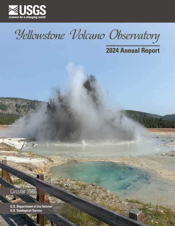
Front cover of Yellowstone Volcano Observatory 2024 annual report
Front cover of Yellowstone Volcano Observatory 2024 annual reportFront cover of the Yellowstone Volcano Observatory 2024 annual report, which includes a summary of earthquake, deformation, and geyser activity, as well as research investigations and other information. The report is freely available online at https://pubs.usgs.gov/publication/cir1566.
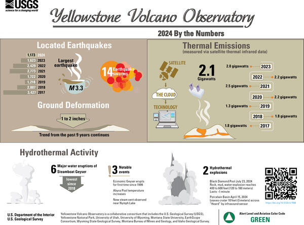
Infographic giving earthquake, deformation, thermal emission, and geyser statistics for the Yellowstone region for the year 2024
Infographic giving earthquake, deformation, thermal emission, and geyser statistics for the Yellowstone region for the year 2024Infographic giving earthquake, deformation, thermal emission, and geyser statistics for the Yellowstone region for the year 2024. The graphic accompanies the Yellowstone Volcano Observatory 2024 annual report, freely available online at https://pubs.usgs.gov/publication/cir1566.
")
The New Norris Hot Spring (Yellowstone Monthly Update - March 2026)
The New Norris Hot Spring (Yellowstone Monthly Update - March 2026)KABOOM! That’s what Yellowstone is famous for – huge explosive volcanic eruptions. There’s really nothing brewing right now, the magma chamber is mostly solid, but there have been quite a few hydrothermal eruptions and small explosions in both Biscuit Basin and Norris Geyser Basin as water in the hydrothermal system flashes to steam.
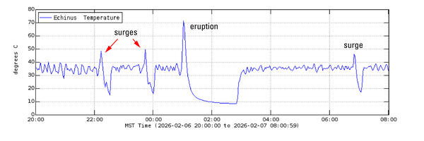
Echinus temperature record during February 6-7, 2026
Echinus temperature record during February 6-7, 2026Temperature record from Echinus Geyser outflow channel for February 6, 2026, at 8 p.m. MST to February 7, 2026, at 8 a.m. MST. The plot shows initial baseline temperatures, then two spikes to 50 °C representing water surges, then an eruption marked by a spike to 70 °C followed by a lull to 10 °C, and finally a return to baseline.
")
Measuring Moving Mountains (Yellowstone monthly update - February 2026)
Measuring Moving Mountains (Yellowstone monthly update - February 2026)Meet a friend of ours. This friend has been monitoring changes of the ground surface in Yellowstone for decades and is so good that it can detect movement of just a few millimeters in magnitude (just a fraction of an inch). The friend? A continuous GPS station!
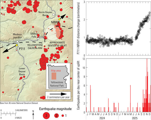
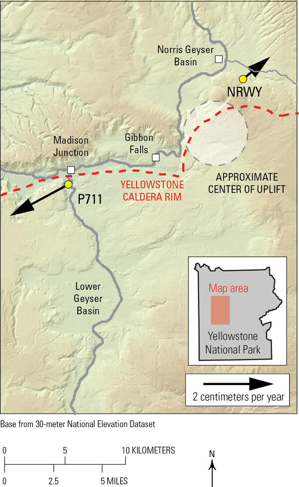
Deformation and seismicity during 2024-2025 associated with Norris Uplift Anomaly, Yellowstone National Park
Deformation and seismicity during 2024-2025 associated with Norris Uplift Anomaly, Yellowstone National ParkMap of horizontal velocities between July and December 2025 at Global Positioning System (GPS) stations P711 and NRWY (arrows and yellow circles; arrow length gives displacement rate) in the area between Norris Geyser Basin and Madison Junction. Dashed black line indicates boundary of Yellowstone Caldera and gray lines are roads.
")
Top 5 Yellowstone geological stories of 2025 (Yellowstone monthly update - January 2026)
Top 5 Yellowstone geological stories of 2025 (Yellowstone monthly update - January 2026)Happy New Year! Let's go back and take a look at the top five geologic stories for Yellowstone in 2025.
Number five: Rumors. It was a year of internet rumors, mostly related to animals fleeing the park, and none of which were true.
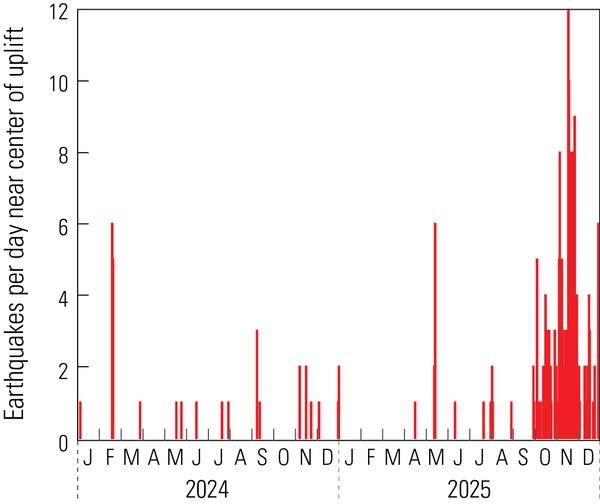
Plot of daily earthquakes located in the area of the Norris Uplift Anomaly during 2024-2025
Plot of daily earthquakes located in the area of the Norris Uplift Anomaly during 2024-2025Plot of numbers of earthquakes per day in the immediate vicinity of the Norris Uplift Anomaly during 2024-2025. An increase in the rate of seismicity occurred in September-December 2025, especially in November. The largest earthquake during that time was M2.7.
Horizontal GPS velocities during July-December 2025 in the Madison and Norris areas of Yellowstone National Park
Horizontal GPS velocities during July-December 2025 in the Madison and Norris areas of Yellowstone National ParkMap of horizontal velocities between July and December 2025 at Global Positioning System (GPS) stations P711 and NRWY (arrows and yellow circles) in the area between Norris Geyser Basin and Madison Junction. Dashed red line indicates boundary of Yellowstone Caldera and gray lines are roads.
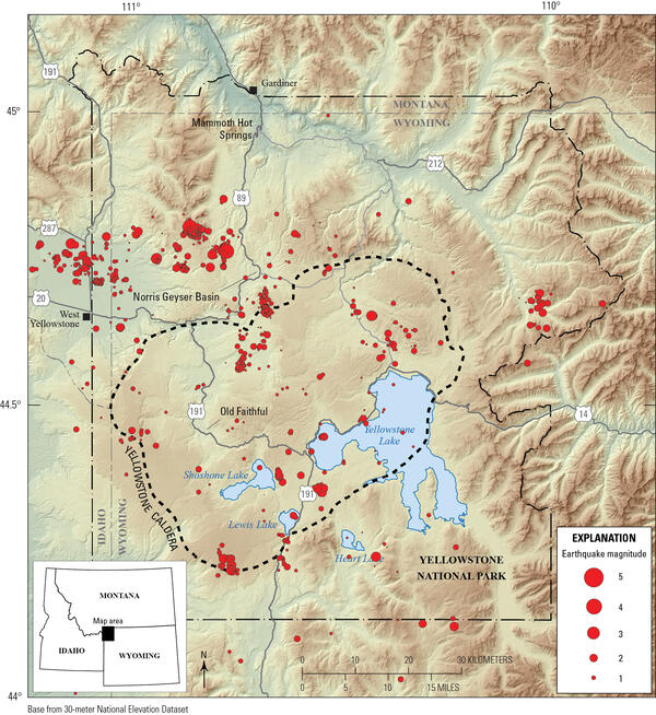
Map of Yellowstone seismicity in 2025
Map of seismicity (red circles) in the Yellowstone region during 2025. Gray lines are roads, black dashed line shows the caldera boundary, Yellowstone National Park is outlined by black dot-dashed line, and gray dashed lines denote state boundaries.
Map of seismicity (red circles) in the Yellowstone region during 2025. Gray lines are roads, black dashed line shows the caldera boundary, Yellowstone National Park is outlined by black dot-dashed line, and gray dashed lines denote state boundaries.
")
Hawaii versus Yellowstone (Yellowstone monthly update - December 2025)
Hawaii versus Yellowstone (Yellowstone monthly update - December 2025)Just last week, Kīlauea put on another dramatic display of lava fountaining and flows within the caldera, during its 37th episode of this most recent eruption. It doesn't seem like Hawaii and Yellowstone have a lot in common, but actually, those two magmatic systems have a common cause.

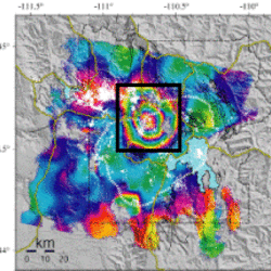
InSAR data from the Yellowstone region spanning October 7, 2024 to October 2, 2025
InSAR data from the Yellowstone region spanning October 7, 2024 to October 2, 2025Interferogram created from satellite radar data collected on October 7, 2024, and October 2, 2025, over the Yellowstone region by the Sentinel-1 satellite system. Colored fringes indicate a change in distance (called range change) between the satellite and ground surface that is caused by surface deformation during the time spanned.
")
Emergency fix at a Yellowstone monitoring site (Yellowstone Monthly Update October 2025)
Emergency fix at a Yellowstone monitoring site (Yellowstone Monthly Update October 2025)The Yellowstone caldera is vast – 45 miles across by 30 miles wide. You could fit over 60 islands of Manhattan in this area. There are deep canyons, like the one on the Yellowstone River, that reveal a complex geologic history. And, forested landscapes and features remind us that this special place is ever-changing.
Science and Products
Uplift along the north rim of Yellowstone Caldera
An area on the north rim of Yellowstone caldera, to the south of Norris Geyser Basin, started to uplift slightly in July 2025. Similar deformation occurred in the same area during 1996-2004 and reveals characteristics of the subsurface.
Optimizing satellite resources for the global assessment and mitigation of volcanic hazards
A vast number of the world’s volcanoes are unmonitored by ground-based sensors, yet constitute an important hazard to nearby residents and infrastructure, as well as air travel and the global economy. Satellite data provide a cost-effective means of tracking activity at such volcanoes. Unfortunately, satellite acquisitions are not optimized for application to volcano hazards, in part...
Filter Total Items: 172
Biscuit Basin webcam
The camera view is east-southeast from the seismic/infrasound monitoring station in Biscuit Basin, Yellowstone National Park.
The camera view is east-southeast from the seismic/infrasound monitoring station in Biscuit Basin, Yellowstone National Park.
Another hydrothermal explosion at Biscuit Basin (Yellowstone Monthly Update - June 2026)
Another hydrothermal explosion at Biscuit Basin (Yellowstone Monthly Update - June 2026)On June 13, 2026, Yellowstone National Park’s newest geophysical monitoring sites captured a small hydrothermal explosion in Biscuit Basin! That story is the subject of this month’s video update.
Water spouting on June 18, 2026, from a new thermal pool that formed shortly after a small hydrothermal explosion at Biscuit Basin, Yellowstone National Park, on June 13, 2026
Water spouting on June 18, 2026, from a new thermal pool that formed shortly after a small hydrothermal explosion at Biscuit Basin, Yellowstone National Park, on June 13, 2026This video is from the Biscuit Basin camera, which is located on the boardwalk adjacent to Black Diamond Pool (the blue-water feature in the foreground) and looking to the north. Black Diamond Pool was the site of a hydrothermal explosion on July 23, 2024, and the pool has erupted numerous times since that event.
Water spouting on June 18, 2026, from a new thermal pool that formed shortly after a small hydrothermal explosion at Biscuit Basin, Yellowstone National Park, on June 13, 2026
Water spouting on June 18, 2026, from a new thermal pool that formed shortly after a small hydrothermal explosion at Biscuit Basin, Yellowstone National Park, on June 13, 2026Water spouting on June 18, 2026, from a new thermal pool that formed shortly after a small hydrothermal explosion at Biscuit Basin, Yellowstone National Park, on June 13, 2026
Water spouting on June 18, 2026, from a new thermal pool that formed shortly after a small hydrothermal explosion at Biscuit Basin, Yellowstone National Park, on June 13, 2026This video is from the Biscuit Basin camera, which is located on the boardwalk adjacent to Black Diamond Pool (the blue-water feature in the foreground) and looking to the north. Black Diamond Pool was the site of a hydrothermal explosion on July 23, 2024, and the pool has erupted numerous times since that event.
Video of small hydrothermal explosion at Biscuit Basin on June 13, 2026
Video of small hydrothermal explosion at Biscuit Basin on June 13, 2026Video from a research and monitoring camera located at Biscuit Basin, Yellowstone National Park, recorded between 05:09:45 and 05:10:15 a.m. MDT on June 13, 2026. Black Diamond Pool, site of a hydrothermal explosion on July 23, 2024, is steaming in the foreground. At about 05:09:50 a.m.
Screen capture showing onset of a small hydrothermal explosion at Biscuit Basin, Yellowstone National Park, on June 13, 2026
Screen capture showing onset of a small hydrothermal explosion at Biscuit Basin, Yellowstone National Park, on June 13, 2026Screen capture showing the view from the Biscuit Basin research and monitoring camera at 05:09:54 a.m. MDT on June 13, 2026. Black Diamond Pool is in the foreground, and a steam plume in the upper right marks the occurrence of a small hydrothermal explosion behind (to the north of) the pool.
Top visitor questions about Yellowstone's thermal areas (Yellowstone Monthly Update - June 2026)
Top visitor questions about Yellowstone's thermal areas (Yellowstone Monthly Update - June 2026)Summer is here, and millions of people will be visiting Yellowstone National Park. People with questions. What is this scat I’m seeing? How does a geyser erupt? What makes Yellowstone so special?
Where’s the bathroom?
Roaring Mountain (Yellowstone Monthly Update - May 2026)
Roaring Mountain (Yellowstone Monthly Update - May 2026)Did you hear that??? Well, Roaring Mountain isn’t quite as loud as it used to be, but it’s still one of the hottest thermal areas in all of Yellowstone National Park!
Roaring Mountain (Yellowstone Monthly Update - May 2026)
Roaring Mountain (Yellowstone Monthly Update - May 2026)Did you hear that??? Well, Roaring Mountain isn’t quite as loud as it used to be, but it’s still one of the hottest thermal areas in all of Yellowstone National Park!
Lone Star Geyser (Yellowstone Monthly Update - April 2026)
Lone Star Geyser (Yellowstone Monthly Update - April 2026)What do Yellowstone National Park and your father's brother's nephew's cousin's former roommate have in common? LONE STAR!!!!!
Lone Star is not just an iconic movie hero of the 1980s (and also next year!). It’s an iconic Yellowstone geyser as well!
Front cover of Yellowstone Volcano Observatory 2024 annual report
Front cover of Yellowstone Volcano Observatory 2024 annual reportFront cover of the Yellowstone Volcano Observatory 2024 annual report, which includes a summary of earthquake, deformation, and geyser activity, as well as research investigations and other information. The report is freely available online at https://pubs.usgs.gov/publication/cir1566.
Infographic giving earthquake, deformation, thermal emission, and geyser statistics for the Yellowstone region for the year 2024
Infographic giving earthquake, deformation, thermal emission, and geyser statistics for the Yellowstone region for the year 2024Infographic giving earthquake, deformation, thermal emission, and geyser statistics for the Yellowstone region for the year 2024. The graphic accompanies the Yellowstone Volcano Observatory 2024 annual report, freely available online at https://pubs.usgs.gov/publication/cir1566.
The New Norris Hot Spring (Yellowstone Monthly Update - March 2026)
The New Norris Hot Spring (Yellowstone Monthly Update - March 2026)KABOOM! That’s what Yellowstone is famous for – huge explosive volcanic eruptions. There’s really nothing brewing right now, the magma chamber is mostly solid, but there have been quite a few hydrothermal eruptions and small explosions in both Biscuit Basin and Norris Geyser Basin as water in the hydrothermal system flashes to steam.
Echinus temperature record during February 6-7, 2026
Echinus temperature record during February 6-7, 2026Temperature record from Echinus Geyser outflow channel for February 6, 2026, at 8 p.m. MST to February 7, 2026, at 8 a.m. MST. The plot shows initial baseline temperatures, then two spikes to 50 °C representing water surges, then an eruption marked by a spike to 70 °C followed by a lull to 10 °C, and finally a return to baseline.
Measuring Moving Mountains (Yellowstone monthly update - February 2026)
Measuring Moving Mountains (Yellowstone monthly update - February 2026)Meet a friend of ours. This friend has been monitoring changes of the ground surface in Yellowstone for decades and is so good that it can detect movement of just a few millimeters in magnitude (just a fraction of an inch). The friend? A continuous GPS station!
Deformation and seismicity during 2024-2025 associated with Norris Uplift Anomaly, Yellowstone National Park
Deformation and seismicity during 2024-2025 associated with Norris Uplift Anomaly, Yellowstone National ParkMap of horizontal velocities between July and December 2025 at Global Positioning System (GPS) stations P711 and NRWY (arrows and yellow circles; arrow length gives displacement rate) in the area between Norris Geyser Basin and Madison Junction. Dashed black line indicates boundary of Yellowstone Caldera and gray lines are roads.
Top 5 Yellowstone geological stories of 2025 (Yellowstone monthly update - January 2026)
Top 5 Yellowstone geological stories of 2025 (Yellowstone monthly update - January 2026)Happy New Year! Let's go back and take a look at the top five geologic stories for Yellowstone in 2025.
Number five: Rumors. It was a year of internet rumors, mostly related to animals fleeing the park, and none of which were true.
Plot of daily earthquakes located in the area of the Norris Uplift Anomaly during 2024-2025
Plot of daily earthquakes located in the area of the Norris Uplift Anomaly during 2024-2025Plot of numbers of earthquakes per day in the immediate vicinity of the Norris Uplift Anomaly during 2024-2025. An increase in the rate of seismicity occurred in September-December 2025, especially in November. The largest earthquake during that time was M2.7.
Horizontal GPS velocities during July-December 2025 in the Madison and Norris areas of Yellowstone National Park
Horizontal GPS velocities during July-December 2025 in the Madison and Norris areas of Yellowstone National ParkMap of horizontal velocities between July and December 2025 at Global Positioning System (GPS) stations P711 and NRWY (arrows and yellow circles) in the area between Norris Geyser Basin and Madison Junction. Dashed red line indicates boundary of Yellowstone Caldera and gray lines are roads.
Map of Yellowstone seismicity in 2025
Map of seismicity (red circles) in the Yellowstone region during 2025. Gray lines are roads, black dashed line shows the caldera boundary, Yellowstone National Park is outlined by black dot-dashed line, and gray dashed lines denote state boundaries.
Map of seismicity (red circles) in the Yellowstone region during 2025. Gray lines are roads, black dashed line shows the caldera boundary, Yellowstone National Park is outlined by black dot-dashed line, and gray dashed lines denote state boundaries.
Hawaii versus Yellowstone (Yellowstone monthly update - December 2025)
Hawaii versus Yellowstone (Yellowstone monthly update - December 2025)Just last week, Kīlauea put on another dramatic display of lava fountaining and flows within the caldera, during its 37th episode of this most recent eruption. It doesn't seem like Hawaii and Yellowstone have a lot in common, but actually, those two magmatic systems have a common cause.
InSAR data from the Yellowstone region spanning October 7, 2024 to October 2, 2025
InSAR data from the Yellowstone region spanning October 7, 2024 to October 2, 2025Interferogram created from satellite radar data collected on October 7, 2024, and October 2, 2025, over the Yellowstone region by the Sentinel-1 satellite system. Colored fringes indicate a change in distance (called range change) between the satellite and ground surface that is caused by surface deformation during the time spanned.
Emergency fix at a Yellowstone monitoring site (Yellowstone Monthly Update October 2025)
Emergency fix at a Yellowstone monitoring site (Yellowstone Monthly Update October 2025)The Yellowstone caldera is vast – 45 miles across by 30 miles wide. You could fit over 60 islands of Manhattan in this area. There are deep canyons, like the one on the Yellowstone River, that reveal a complex geologic history. And, forested landscapes and features remind us that this special place is ever-changing.
*Disclaimer: Listing outside positions with professional scientific organizations on this Staff Profile are for informational purposes only and do not constitute an endorsement of those professional scientific organizations or their activities by the USGS, Department of the Interior, or U.S. Government