Mapping nearshore depths along a beach

Detailed Description
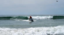
Cordell Johnson uses a personal watercraft (PWC) equipped with GPS and sonar to measure seafloor depths near the beach.
Sources/Usage
Public Domain.

Official websites use .gov
A .gov website belongs to an official government organization in the United States.
Secure .gov websites use HTTPS
A lock () or https:// means you’ve safely connected to the .gov website. Share sensitive information only on official, secure websites.
Cordell Johnson uses a personal watercraft (PWC) equipped with GPS and sonar to measure seafloor depths near the beach.
Public Domain.