
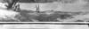
Men from trip with E.C. LaRue on the Colorado River; image cropped

Detailed Description
Repeat photography of Colorado River Mile 197, originally photographed by E.C. LaRue during the 1923 Birdseye Expedition
Eugene Clyde LaRue was an engineer for the USGS until 1927. He conducted investigations for potential dam sites, irrigation systems, and power generation. He was interested in Colorado River water development, and became the chairman of the Arizona Engineering Commission in 1922. In 1923, the Birdseye Expedition surveyed the 251-mile stretch of the Colorado River In Grand Canyon between Lees Ferry and Diamond Creek. E.C. LaRue served as the expedition's hydrologist and photographer. The two major goals of the expedition were to locate potential dam sites and create a series of maps and profiles of the area. Eventually, the expedition published 14 maps that were used in the creation of Hoover and Parker Dams, as well as the Colorado River Aqueduct and the Central Arizona Project (courtesy of ArchivesWest, Orbis Cascade Alliance). The 1923 image was taken along the Colorado River, at River Mile 197, from the left bank, and repeat images were taken by the USGS in 1972, 1983, 1994, and 2016. The series is stored in the SBSC's Southwest Repeat Photography Collection, stake (camera point) s0720, original numbers (LaRue) 628 and 629. Dates and descriptions of each image are below.
This image shows men from E.C. LaRue's crew on a sandbar during a survey trip on the Colorado River taken in 1923. The photo caption says, "Forty miles below Havasu Creek. Lunch time and the crew at play while waiting for a side canyon survey to be completed. 9-23-1923."
Sources/Usage
Public Domain.