
NGWOS Small Drone Training in Maryland

Detailed Description
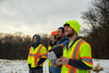
Nick Giro, Chris Lewis, Leah Staub, and Jeremy Malen observing a small aerial drone (off camera) during training.
The USGS is testing drones as a safer means for technicians to measure streamflow during flooding.
The idea is to measure stream velocity using a high-resolution camera mounted to the drone flying above the river, allowing us to measure during floods from a safe distance.
Our ability to measure streamflow with this method is still in its early stages, and this project is part of the Next Generation Water Observing System (NGWOS), a program which develops innovative ways to improve water science and keep communities informed during extreme events.
Sources/Usage
Public Domain.