
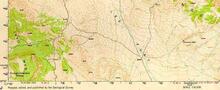
Portion of USGS Topographic Map of Ubehebe Peak, CA
By Earth Resources Observation and Science (EROS) Center
2000 (approx.)

Detailed Description
Portion of United States Geological Survey topographic map of Ubehebe Peak, California. Wavy lines in the map are topographic contours. Numbers in the map represent the elevation in feet above sea level.
Sources/Usage
Public Domain.
Related

USGS EROS Archive - Digital Elevation - Why Map the World with Radar?
Have you ever seen a map that shows not only the location of features on the Earth, but also how high or low they are? This information is known as topography, and maps which display elevation information are called topographic maps.
Related
USGS EROS Archive - Digital Elevation - Why Map the World with Radar?
Have you ever seen a map that shows not only the location of features on the Earth, but also how high or low they are? This information is known as topography, and maps which display elevation information are called topographic maps.