
Regional Groundwater Flow Paths from PFAS sources OFR 2019-1137

Detailed Description
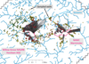
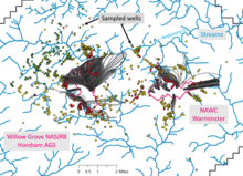
Figure 33 from Open-File Report 2019-1137 shows composite simulated regional groundwater-flow paths from possible per- and polyfluoroalkyl substances (PFAS) contamination sources at Willow Grove and Warminster for conditions in 1999, 2010, 2013, 2016, and 2017 and maximum levels of perfluorooctane sulfonate (PFOS) and perfluorooctanoic acid (PFOA) in 2014–2018 well-water samples relative to drinking-water health advisories (green, nondetect PFOS & POA; yellow, PFOS+PFOA less than 40 parts per trillion (ppt), orange, less than 70 ppt, red, 70 or greater ppt). Water-quality data from the U.S. Navy (written commun., 2019).
Open-File Report 2019-1137, Groundwater Withdrawals and Regional Flow Paths at and near Willow Grove and Warminster, Pennsylvania—Data Compilation and Preliminary Simulations for Conditions in 1999, 2010, 2013, 2016, and 2017, is available at https://doi.org/10.3133/ofr20191137.
Sources/Usage
Public Domain.
USGS Open-File Report 2019-1137
Goode, D.J., and Senior, L.A., 2020, Groundwater withdrawals and regional flow paths at and near Willow Grove and Warminster, Pennsylvania—Data compilation and preliminary simulations for conditions in 1999, 2010, 2013, 2016, and 2017: U.S. Geological Survey Open-File Report 2019–1137, 127 p., https://doi.org/10.3133/ofr20191137.