
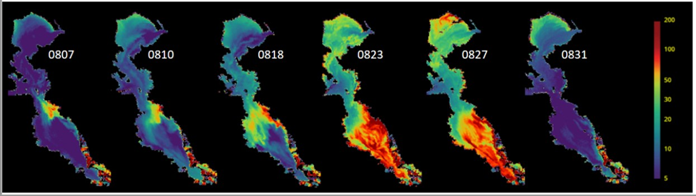
Remotely sensed chlorophyll estimates during the 2022 HAB event.
Detailed Description
Remotely sensed chlorophyll estimates during the 2022 HAB event (mg m-3). Data are from the ESA Sentinel-3 satellite and are processed using a locally tuned algorithm for San Francisco Bay. Image courtesy of the San Francisco Estuary Institute.
The color scale at the right edge representing the level of chlorophyll concentrations in the water as measured from satellite remote sensing. Each map corresponds to a single satellite image of the Bay on collected on August 7, 10, 18, 23, 27, and 31, 2022. The consecutive images, show the bloom developing on August 8 and 10 around Alameda Island, then expanding throughout the South Bay on August 18, 23 and 27. On August 31, the bloom had already ended and chlorophyll concentrations had returned to pre-bloom levels.
Sources/Usage
Public Domain.
Related
WaterMAP: Water Monitoring Above the Planet
Related