
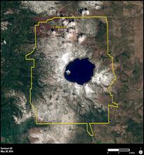
Sentinel 2A View of Crater Lake National Park

Detailed Description
A Sentinel 2A image of Crater Lake National Park in Oregon. Taken on May 28, 2016. Credit: European Space Agency.
Sources/Usage
Related
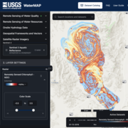
WaterMAP: Water Monitoring Above the Planet
WaterMAP, or Water Monitoring Above the Planet, is an interactive web application that brings together surface water observations across the U.S. The application allows users to explore water conditions over time using both remotely sensed satellite and field measured data.
Related
WaterMAP: Water Monitoring Above the Planet
WaterMAP, or Water Monitoring Above the Planet, is an interactive web application that brings together surface water observations across the U.S. The application allows users to explore water conditions over time using both remotely sensed satellite and field measured data.