
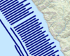
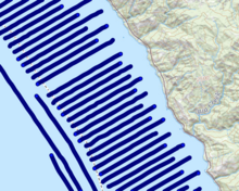
Ship tracklines of seafloor magnetic data
By Pacific Coastal and Marine Science Center
2011 (approx.)

Detailed Description
Map shows just a portion of the ship tracklines, or "path" that the ship followed, while collecting marine magnetic data.
Sources/Usage
Public Domain.
Marine magnetic data from Point Sur to Piedras Blancas, central California, 2011
This dataset includes marine magnetic data collected by the U.S. Geological Survey (USGS) in 2011 during field activity B-05-11-CC between Point Sur and Piedras Blancas, central California.