
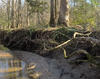
Simms Branch, Durant Nature Preserve, Raleigh, NC

Detailed Description
Simms Branch, Durant Nature Preserve, Raleigh, NC
Sources/Usage
Public Domain.
Related

Raleigh Bank Erosion Project
The City of Raleigh partnered with the U.S. Geological Survey (USGS) to assist in assessing streambank erosion hotspots along the City of Raleigh’s stream network to support the City’s efforts of prioritizing future stream mitigation projects. Streambank erosion potential will be assessed using remotely sensed light detection and ranging (lidar) data, field assessments of streambank conditions...
Related
Raleigh Bank Erosion Project
The City of Raleigh partnered with the U.S. Geological Survey (USGS) to assist in assessing streambank erosion hotspots along the City of Raleigh’s stream network to support the City’s efforts of prioritizing future stream mitigation projects. Streambank erosion potential will be assessed using remotely sensed light detection and ranging (lidar) data, field assessments of streambank conditions...