
High water in the Walnut Creek watershed in Raleigh, North Carolina, in 2022. Flooding can impact nearby infrastructure, including homes, businesses, roads and trails. Credit: Kristina Hopkins, USGS.
Kristina Hopkins
Krissy Hopkins is a Supervisory Research Physical Scientist for the Watersheds and Fluvial Systems Section at the Washington Water Science Center.
The Watersheds and Fluvial Systems Section conducts studies of watersheds and the rivers and streams flowing through them to understand geomorphic conditions, sediment dynamics, and ecosystem functions. This includes sediment sampling and coring, geospatial analyses, remote sensing, and empirical modeling of biophysical processes.
Krissy’s expertise focuses on understanding the impacts of land use change on hydrologic, geochemical, geomorphic, and ecological functions within freshwater ecosystems. This includes examining the impacts of different types of stormwater management strategies such as rain gardens and other green infrastructure. Her work also focuses on translating ecosystem functions into ecosystem services and values by applying ecosystem services approaches to floodplain systems and green stormwater infrastructure.
Science and Products
Filter Total Items: 13
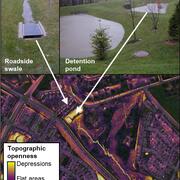
Remotely mapping stormwater facility footprints and storage volumes
Stormwater management practices are being used throughout the Chesapeake Bay watershed to reduce flood risks and pollutant loads, but consistent and comprehensive maps of these practices are often lacking. Stormwater managers often have incomplete information about the location and storage volume of stormwater facilities within their jurisdiction. Therefore, the USGS is working to develop...

Raleigh Bank Erosion Project
The City of Raleigh partnered with the U.S. Geological Survey (USGS) to assist in assessing streambank erosion hotspots along the City of Raleigh’s stream network to support the City’s efforts of prioritizing future stream mitigation projects. Streambank erosion potential will be assessed using remotely sensed light detection and ranging (lidar) data, field assessments of streambank conditions...
Integrating Stormwater Drainage into USGS StreamStats Application for the Duwamish and Lower Green River
The U.S. Geological Survey (USGS) is developing a Duwamish and Lower Green River Storm Drain StreamStats application to help communities and decision-makers address stormwater challenges in the Duwamish and lower Green River watershed. This free, publicly accessible tool will allow users to delineate stormwater drainage areas and calculate basin characteristics, supporting climate resiliency and...
Carbon in Urban River Biogeochemistry Project
The Issue: In aquatic ecosystems, dissolved organic carbon represents the largest flux of carbon in streams and it is a primary energy source in aquatic food webs. There is limited understanding of how human activities related to urban development influence the timing and scale of carbon cycling in aquatic ecosystems. How USGS will help: The USGS is working with university partners to assess how...

Integration of Urban Stormwater Infrastructure in Modeling Water Quality Patterns in Small Urban Streams
The Issue: Stormwater can quickly run off impervious surfaces delivering potentially polluted water to streams and rivers in the Puget Sound region. Runoff from impervious surfaces can either be directly connected to streams through stormwater pipes or indirectly connected if runoff is routed to some other surface such as grass or a feature like a stormwater management structure. It is currently...

Understanding the Effects of Stormwater Management Practices on Water Quality and Flow
Urban development can have detrimental impacts on streams including altering hydrology, increasing nutrient, sediment, and pollutant loadings, and degrading biological integrity. Stormwater Best Management Practices (BMPs) can be used to mitigate the effects of urban development by retaining large volumes of stormwater runoff and treating runoff to remove pollutants. This project focuses on...

Floodplains provide millions of dollars in benefits every year to people in the Chesapeake Bay and Delaware River watersheds
Issue: Floodplains provide important services to people by retaining sediments, nutrients, and floodwaters, thereby improving water quality and reducing flooding impacts. Having information on how the monetary benefit that floodplains provide varies across the Chesapeake Bay and Delaware River watersheds helps resource managers describe the benefits that floodplains provide in their current state...

Unique 20-year study assesses ecosystem response to different types of stormwater management
Issue: Managing stormwater runoff in developing areas

Assessment of Sediment Quality and Volume behind Enloe Dam
The U.S. Geological Survey (USGS) completed a pair of scientific studies to determine the volume and quality of sediment stored behind Enloe Dam in north-central Washington.

New dataset available on stream and floodplain geometry to inform restoration decisions
Issue: The need for stream mapping The physical shape of streams and floodplains can provide information about how water, sediment, and other matter moves through the landscape. Streams can have deep channels (tall streambanks) disconnected from the floodplain or wide shallow channels that easily spill over the banks into the floodplain during high flows. Mapping where streams fall along this...

New Insights on using Green Stormwater Infrastructure to Reduce Suburban Runoff
The Issue with Runoff Across the United States, suburban development is replacing agricultural and forested lands. In urban and suburban areas, large amounts of stormwater runoff are generated from rooftops and roadways during rain events. Runoff is quickly piped to streams and rivers, leading to flash flooding, stream bank erosion, and damages to stream health. Reducing nutrients, sediment, and...

SPARROW Modeling for North Carolina Watersheds
In North Carolina, excessive nutrient and sediment loadings have contributed to the degradation of surface-water quality across the state as a result of agricultural activities and population growth increases. To further understand the influences of human activities and natural processes on surface-water quality, the U.S. Geological Survey (USGS) developed the SPARROW (SPAtially Referenced...

High water in the Walnut Creek watershed
High water in the Walnut Creek watershed in Raleigh, North Carolina, in 2022. Flooding can impact nearby infrastructure, including homes, businesses, roads and trails. Credit: Kristina Hopkins, USGS.

Soaking Up Stormwater
This video acts as a “visual abstract” for a recent publication analyzing the stormwater management practices in Clarksburg, MD. The video features interviews with the team of USGS scientists as well as a water specialist from Montgomery County.
This video acts as a “visual abstract” for a recent publication analyzing the stormwater management practices in Clarksburg, MD. The video features interviews with the team of USGS scientists as well as a water specialist from Montgomery County.
Soaking Up Stormwater (AD)
This video acts as a “visual abstract” for a recent publication analyzing the stormwater management practices in Clarksburg, MD. The video features interviews with the team of USGS scientists as well as a water specialist from Montgomery County.
This video acts as a “visual abstract” for a recent publication analyzing the stormwater management practices in Clarksburg, MD. The video features interviews with the team of USGS scientists as well as a water specialist from Montgomery County.

Sand filter and dry detention pond located in Clarksburg, Maryland
Sand filter and dry detention pond located in Clarksburg, MarylandPhotograph of sand filter and dry detention pond located in Clarksburg, Maryland.
Sand filter and dry detention pond located in Clarksburg, Maryland
Sand filter and dry detention pond located in Clarksburg, MarylandPhotograph of sand filter and dry detention pond located in Clarksburg, Maryland.
Science and Products
Filter Total Items: 13
Remotely mapping stormwater facility footprints and storage volumes
Stormwater management practices are being used throughout the Chesapeake Bay watershed to reduce flood risks and pollutant loads, but consistent and comprehensive maps of these practices are often lacking. Stormwater managers often have incomplete information about the location and storage volume of stormwater facilities within their jurisdiction. Therefore, the USGS is working to develop...
Raleigh Bank Erosion Project
The City of Raleigh partnered with the U.S. Geological Survey (USGS) to assist in assessing streambank erosion hotspots along the City of Raleigh’s stream network to support the City’s efforts of prioritizing future stream mitigation projects. Streambank erosion potential will be assessed using remotely sensed light detection and ranging (lidar) data, field assessments of streambank conditions...
Integrating Stormwater Drainage into USGS StreamStats Application for the Duwamish and Lower Green River
The U.S. Geological Survey (USGS) is developing a Duwamish and Lower Green River Storm Drain StreamStats application to help communities and decision-makers address stormwater challenges in the Duwamish and lower Green River watershed. This free, publicly accessible tool will allow users to delineate stormwater drainage areas and calculate basin characteristics, supporting climate resiliency and...
Carbon in Urban River Biogeochemistry Project
The Issue: In aquatic ecosystems, dissolved organic carbon represents the largest flux of carbon in streams and it is a primary energy source in aquatic food webs. There is limited understanding of how human activities related to urban development influence the timing and scale of carbon cycling in aquatic ecosystems. How USGS will help: The USGS is working with university partners to assess how...
Integration of Urban Stormwater Infrastructure in Modeling Water Quality Patterns in Small Urban Streams
The Issue: Stormwater can quickly run off impervious surfaces delivering potentially polluted water to streams and rivers in the Puget Sound region. Runoff from impervious surfaces can either be directly connected to streams through stormwater pipes or indirectly connected if runoff is routed to some other surface such as grass or a feature like a stormwater management structure. It is currently...
Understanding the Effects of Stormwater Management Practices on Water Quality and Flow
Urban development can have detrimental impacts on streams including altering hydrology, increasing nutrient, sediment, and pollutant loadings, and degrading biological integrity. Stormwater Best Management Practices (BMPs) can be used to mitigate the effects of urban development by retaining large volumes of stormwater runoff and treating runoff to remove pollutants. This project focuses on...
Floodplains provide millions of dollars in benefits every year to people in the Chesapeake Bay and Delaware River watersheds
Issue: Floodplains provide important services to people by retaining sediments, nutrients, and floodwaters, thereby improving water quality and reducing flooding impacts. Having information on how the monetary benefit that floodplains provide varies across the Chesapeake Bay and Delaware River watersheds helps resource managers describe the benefits that floodplains provide in their current state...
Unique 20-year study assesses ecosystem response to different types of stormwater management
Issue: Managing stormwater runoff in developing areas
Assessment of Sediment Quality and Volume behind Enloe Dam
The U.S. Geological Survey (USGS) completed a pair of scientific studies to determine the volume and quality of sediment stored behind Enloe Dam in north-central Washington.
New dataset available on stream and floodplain geometry to inform restoration decisions
Issue: The need for stream mapping The physical shape of streams and floodplains can provide information about how water, sediment, and other matter moves through the landscape. Streams can have deep channels (tall streambanks) disconnected from the floodplain or wide shallow channels that easily spill over the banks into the floodplain during high flows. Mapping where streams fall along this...
New Insights on using Green Stormwater Infrastructure to Reduce Suburban Runoff
The Issue with Runoff Across the United States, suburban development is replacing agricultural and forested lands. In urban and suburban areas, large amounts of stormwater runoff are generated from rooftops and roadways during rain events. Runoff is quickly piped to streams and rivers, leading to flash flooding, stream bank erosion, and damages to stream health. Reducing nutrients, sediment, and...
SPARROW Modeling for North Carolina Watersheds
In North Carolina, excessive nutrient and sediment loadings have contributed to the degradation of surface-water quality across the state as a result of agricultural activities and population growth increases. To further understand the influences of human activities and natural processes on surface-water quality, the U.S. Geological Survey (USGS) developed the SPARROW (SPAtially Referenced...
High water in the Walnut Creek watershed
High water in the Walnut Creek watershed in Raleigh, North Carolina, in 2022. Flooding can impact nearby infrastructure, including homes, businesses, roads and trails. Credit: Kristina Hopkins, USGS.
High water in the Walnut Creek watershed in Raleigh, North Carolina, in 2022. Flooding can impact nearby infrastructure, including homes, businesses, roads and trails. Credit: Kristina Hopkins, USGS.
Soaking Up Stormwater
This video acts as a “visual abstract” for a recent publication analyzing the stormwater management practices in Clarksburg, MD. The video features interviews with the team of USGS scientists as well as a water specialist from Montgomery County.
This video acts as a “visual abstract” for a recent publication analyzing the stormwater management practices in Clarksburg, MD. The video features interviews with the team of USGS scientists as well as a water specialist from Montgomery County.
Soaking Up Stormwater (AD)
This video acts as a “visual abstract” for a recent publication analyzing the stormwater management practices in Clarksburg, MD. The video features interviews with the team of USGS scientists as well as a water specialist from Montgomery County.
This video acts as a “visual abstract” for a recent publication analyzing the stormwater management practices in Clarksburg, MD. The video features interviews with the team of USGS scientists as well as a water specialist from Montgomery County.
Sand filter and dry detention pond located in Clarksburg, Maryland
Sand filter and dry detention pond located in Clarksburg, MarylandPhotograph of sand filter and dry detention pond located in Clarksburg, Maryland.
Sand filter and dry detention pond located in Clarksburg, Maryland
Sand filter and dry detention pond located in Clarksburg, MarylandPhotograph of sand filter and dry detention pond located in Clarksburg, Maryland.