
USGS Monitoring Well - Climate Response Network near Babbitt, MN

Detailed Description
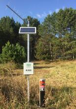
Site photo of a monitoring well for the USGS “Climate Response Network” program near Babbitt, MN. This monitoring well is part of a national network of wells to monitor the effects of droughts and other climate variability on groundwater levels. This site records hourly water level, hourly water temperature, and quarter-hourly precipitation. These data are telemetered hourly and available to view in near real-time on USGS NWISWeb.
Sources/Usage
Credit: Andrew Berg, USGS
Related

Continuous Groundwater Monitoring Network - Minnesota
This project monitors groundwater level, groundwater temperature and precipitation at hourly intervals at a long-term network of sites throughout Minnesota. These data are collected from surficial and buried aquifers and can be used to estimate groundwater recharge and assist water-availability assessments. Data are corrected to manual measurements at least twice per year and are available through...
Related
Continuous Groundwater Monitoring Network - Minnesota
This project monitors groundwater level, groundwater temperature and precipitation at hourly intervals at a long-term network of sites throughout Minnesota. These data are collected from surficial and buried aquifers and can be used to estimate groundwater recharge and assist water-availability assessments. Data are corrected to manual measurements at least twice per year and are available through...