
USGS Prepares to Launch on the Yazoo

Detailed Description
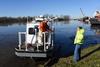
USGS scientists Mike Manning (left) and USGS National Flood Coordinator Bob Holmes discuss plans for the day. USGS crews departed from the U.S. Coast Guard's Vicksburg Office on the Yazoo River to measure streamflow on the Mississippi River.
In late 2015/early 2016, unusually large rainfall in the Upper Mississippi River Valley led to flooding throughout Arkansas, Illinois, Louisiana, Mississippi, Missouri, and Tennessee. USGS water science centers responded to the flooding by measuring the streamflow, collecting water quality information, and providing that information to emergency responders.
Sources/Usage
Public Domain.