
USGS Streamflow Duration Hydrograph for New York

Detailed Description
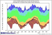
The Duration Hydrograph is a graphical presentation of recent daily streamflow (discharge) observed at an individual USGS streamgage (the black line), plotted over the long-term statistics of streamflow for each day of the year at that station. The statistics, based on quality assured and approved data, include the maximum discharge recorded during the period of record for each day of the year (top of the dark blue area); the 90th percentile flow for each day (top of the light blue area); the interquartile range (the green area bounded by the 75th percentile on top and 25th percentile on the bottom); the 10th percentile flow for each day (the bottom of the orange area); and the minimum discharge recorded for each day (bottom of dark brown area). The plot covers a period of two years with the statistics being identical for each of the two years.
Sources/Usage
Related

New York Drought Information
Related