
Groundwater and Streamflow Information
Surface-water Monitoring, Groundwater monitoring, and Flood Hazards
Surface-water Monitoring, Groundwater monitoring, and Flood Hazards
Water Use and Availability
Surface-water Modeling, Groundwater-flow Modeling, Hydrogeologic Characterization, Water Use, Flood Science, Climate Change
Surface-water Modeling, Groundwater-flow Modeling, Hydrogeologic Characterization, Water Use, Flood Science, Climate Change
Water Quality
Surface-water-quality Monitoring, Groundwater-quality Monitoring, Water-quality Modeling, Wetlands, Ecosystem Health
Surface-water-quality Monitoring, Groundwater-quality Monitoring, Water-quality Modeling, Wetlands, Ecosystem Health
Coastal Science
Beach and Barrier Dynamics, Flood Hazards, Nearshore Environmental Health, Tide and Wave Hydrodynamics, Wetlands, Climate and Land-Use Change
Beach and Barrier Dynamics, Flood Hazards, Nearshore Environmental Health, Tide and Wave Hydrodynamics, Wetlands, Climate and Land-Use Change
Ecosystem Health
Aquatic Community Health, Biogeochemical and Hydrologic Assessment, Climate Change, Ecological Assessment of Human and Natural Impacts
Aquatic Community Health, Biogeochemical and Hydrologic Assessment, Climate Change, Ecological Assessment of Human and Natural Impacts
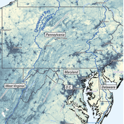
New York Water Science Center
The New York Water Science Center will provide the hydrologic observations, research, and modeling needed for full integration of hydrogeologic, physiochemical, biological, and landscape processes across the freshwater to marine continuum.


NY WSC Quick Links
NY WSC Quick Links
Explore some of our most popular science topics, data, and tools
News
USGS Scientists at the 2026 Long Island Sound Research Conference
USGS Scientists at the 2026 Long Island Sound Research Conference
USGS Satellites and Test Tubes Meet to Ensure Safe Drinking Water
USGS Satellites and Test Tubes Meet to Ensure Safe Drinking Water
Advanced Quantitative Precipitation Information System Enhances Flood Prediction in San Francisco Bay Area
Advanced Quantitative Precipitation Information System Enhances Flood Prediction in San Francisco Bay Area
Publications
Modeling legacy nitrogen transport under instantaneous, steady-state, and transient groundwater flow conditions Modeling legacy nitrogen transport under instantaneous, steady-state, and transient groundwater flow conditions
In hydrologic settings where groundwater discharge contributes substantially to surface waters, legacy nitrogen in groundwater can confound surface water nitrogen loads estimated exclusively from current terrestrial sources. Additionally, legacy nitrogen in groundwater can contribute to lagged responses to nitrogen management efforts. Some methods of estimating groundwater contributions...
Using quantitative polymerase chain reaction to assess phytoplankton and indicate eutrophication in freshwater rivers: A multiyear nationwide study across the United States Using quantitative polymerase chain reaction to assess phytoplankton and indicate eutrophication in freshwater rivers: A multiyear nationwide study across the United States
Phytoplankton are essential primary producers in fresh surface water that are critical to the health of ecosystems. However, phytoplankton overgrowth due to eutrophication threatens ecological, economic, and public health. Therefore, assessing phytoplankton is fundamental for understanding the productivity, health, and trophic status of freshwater ecosystems. Light microscopy and...
Water table rise sustains carbon release from soils in wetland-dominated landscapes: An intact soil core study Water table rise sustains carbon release from soils in wetland-dominated landscapes: An intact soil core study
Wetland-dominated landscapes influence carbon cycling through their potential to act as both carbon sinks and sources. Wetlands in low-relief landscapes have dynamic terrestrial-aquatic interfaces that change seasonally with variable surface water and groundwater levels. However, few studies have directly quantified dissolved organic matter (DOM) release and greenhouse gas (CO2, CH4)...
Science

Well Selection Information for Homeowners and PWS Personnel
Well Selection Information for Homeowners and PWS Personnel
Evaluating the Risks of Tire-Derived Compounds to Fish in the Chesapeake Bay Watershed
Tires contain a chemical known as 6PPD which prevents them from quickly breaking down. Microscopic tire particles, generated mainly from the friction of tires on roads, release 6PPD-quinone (6PPDQ) when they come into contact with oxygen. During precipitation events, 6PPDQ can be washed off roads, harming fish in nearby waterways. In response to requests from fishery managers, the USGS is studying...
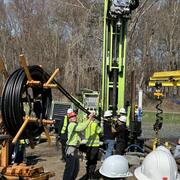
Interactive Products to Assist with Geothermal Drilling
Geothermal energy is a clean and renewable source of heat derived from the Earth's natural thermal resources. Geothermal borefields are utilized to extract this thermal energy, providing heating for buildings in the winter and cooling in the summer. In New York, the adoption of geothermal energy at both residential and community scales is on the rise and is expected to see significant growth in...