
USGS streamgage measures flooding in the lower Trinity River
By Communications and Publishing
March 2015 (approx.)

Detailed Description
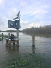
A USGS streamgage measures flooding in the lower Trinity River, Texas.
For the first time, USGS scientists are now collecting real-time sediment and water-quality information on water traveling into Galveston Bay. A better understanding of sediment and freshwater flow into Galveston Bay is now available from a new USGS report, done in cooperation with the Texas Water Development Board, and the Galveston Bay Estuary Program.
Sources/Usage
Public Domain.