
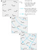
Using altitudes of the water table at individual wells on Long Island

Detailed Description
Using known altitudes of the water table at individual wells (A), contour maps of the water-table surface can be drawn (B), and directions of ground-water flow along the water table can be determined (C) because flow usually is approximately perpendicular to the contours. Groundwater moves along flow paths of varying lengths in transmitting water from areas of recharge to areas of discharge (Winter and others, 1998).
Sources/Usage
Public Domain.
Related

Long Island Water Table and Surface Maps
The depth to the water table can be determined by installing wells that penetrate the top of the saturated zone just far enough to respond to water table fluctuations. Preparation of a water-table map requires that only wells that have their well screens installed near the water table be used. If the depth to water is measured at a number of such wells throughout an area of study, and if those...
Related
Long Island Water Table and Surface Maps
The depth to the water table can be determined by installing wells that penetrate the top of the saturated zone just far enough to respond to water table fluctuations. Preparation of a water-table map requires that only wells that have their well screens installed near the water table be used. If the depth to water is measured at a number of such wells throughout an area of study, and if those...