
Validated modeling and sampling methodology

Detailed Description
Validated modeling and sampling methodology
Sources/Usage
Related

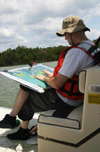
Seagrass Beds and Manatee Foraging Areas in the Ten Thousand Islands: Mapping and Characterizing by Incorporating Manatee GPS Tracking Data and Habitat Information
Turbid water conditions make the delineation and characterization of benthic habitats difficult by traditional in situ and remote sensing methods. Consequently, only a small fraction of this valuable resource has been mapped or characterized.
Related
Seagrass Beds and Manatee Foraging Areas in the Ten Thousand Islands: Mapping and Characterizing by Incorporating Manatee GPS Tracking Data and Habitat Information
Turbid water conditions make the delineation and characterization of benthic habitats difficult by traditional in situ and remote sensing methods. Consequently, only a small fraction of this valuable resource has been mapped or characterized.