
Seven Ways to Access or View USGS Trails Dataset
USGS Trails Dataset is an ongoing effort to aggregate nationwide public domain geospatial data that can be easily viewed or accessed through the USGS as cartographic products, downloadable GIS files, or service endpoints. Learn seven ways to access or view USGS Trails Dataset.
USGS Trails Dataset is an ongoing effort to aggregate public domain trails data from federal, state, and some local partners. The dataset can be easily viewed or accessed through the USGS as cartographic products, downloadable GIS files, or service endpoints. Trails data can be freely incorporated into topographic maps, online web applications, mobile applications, posters, and the list goes on and on. The data can be viewed or downloaded from the following sources:
1. For information about this project and links to data, visit the National Digital Trails website. Either click on the previous link or search the web for “USGS National Digital Trails Project.” Next, click on “Data and Tools” to learn more about data sources.

2. For an easy way to see if the trails that matter to you are part of the USGS trails dataset, visit the USGS Trails Explorer application. Trails Explorer offers a view of USGS nationwide trails dataset over Protected Areas Database of the US (PAD-US) layer. Note: It is a large dataset so it may take a few seconds to load.
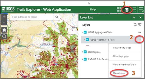
In the Trails Explorer, you can also navigate directly to a map service by 1) clicking on the “Layers List” icon in the top right corner, 2) then click on the three dots next to the “USGS Aggregated Trails” layer, and 3) choose description (see image below).
3. A great way to access and view trails data is to download a US Topo map! You can download, purchase, or view current or historical topographic maps using links on the National Map Data Delivery page.

4. Another way to view the nationwide trails dataset is through the National Map Viewer. The National Map Viewer includes map layers for water, elevation, transportation, structures, land cover, and others. The trails dataset is a feature class in the USGS Transportation Database. You can view trails by 1) expanding the list of layers, then 2) expanding the “Transportation” group, and then 3) clicking on “Trails” under the “Large and Medium Scale” layers (see image below).

5. To download geospatial trails data, you have several options. The first option is to use the National Map Download Manager. In order to obtain trails data, download the USGS National Transportation Database for your area of interest. From the “Find Products” section on the left choose 1) “Transportation;” 2) then check “National Transportation Database,” 3) choose “National” or “State” data extent, 4) and file format, “Shapefile” or “GDB.” See image below for more information.

6. Another option to download USGS trails data is to use the National Map Staged Products Directory. Download a nationwide or state extract of the USGS National Transportation Database (“Tran” as noted in the image below) to access the trails dataset. Files can be downloaded in either shapefile or geodatabase format. Since “Staged Products” are updated periodically, it is a good idea to note the timestamp on the file.

7. For those needing a map or feature service, go to The National Map – Service Endpoints to pull trails data directly into a map or application. Trails can be found in the “Theme Overlays” and under “Web Feature Services” as noted in the image below.
