



US Topo Cartographic Specifications - Map Symbol Guide
US Topo cartographic specifications Map Symbol Guide.
What is a US Topo map?
A US Topo map is a digital topographic map that covers 7.5-minutes of longitude by 7.5-minutes of latitude and is produced at a scale of 1:24,000. US Topo maps are freely distributable and are available for download on the web from The National Map Downloader or from the USGS Store in Portable Document Format (PDF) with geospatial extensions. PDF maps can be viewed and printed with any conforming PDF software. Versions 9.x and later of Adobe® Reader® and Acrobat® software provide access to the geospatial functionality of the US Topo map. A free Adobe Reader download is available. More information about US Topo maps and their use is available at: USGS.gov/USTopo
The base data layer of a US Topo map is a recent orthographic aerial photograph. These orthoimages have been corrected to remove scale distortions that result from the varying terrain and deviations of the aircraft’s position from the true vertical. The maps include contours that show the shape of the Earth’s surface, hydrographic features such as lakes and rivers, roads, boundaries, and geographic names. Additional data from the geographic data themes of transportation, names, elevation, hydrography, boundaries, structures (such as fire stations) and land cover (such as woodland tint) is being added to the maps as they are updated, resulting in a product that will become progressively more robust over time. Feature data is incorporated from national Geographic Information System (GIS) databases under the stewardship of USGS data programs. The US Topo map is intended for conventional map users, not for advanced GIS analysis. However, most of the data sources used are in the public domain and may be downloaded for free from The National Map (TNM).
US Topo maps are revised on a three-year production cycle.
Base content represented in these maps are from The National Map geospatial data themes as follows:
- Transportation, including trails;
- Recreational structures, such as trailheads and campgrounds;
- Boundaries, both jurisdictional and administrative;
- Geographic names, including natural features and populated places;
- Elevation, such as contours and shaded relief;
- Surface hydrography, such as lakes and rivers; and
- Selected land use classifications and orthoimagery.
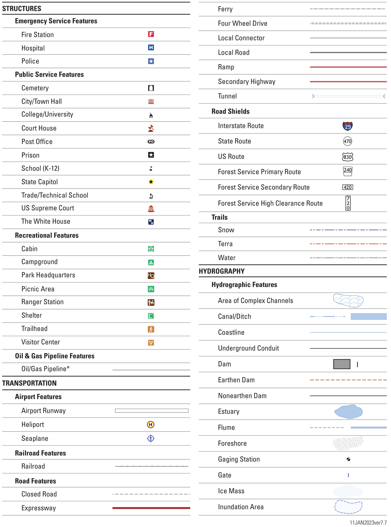
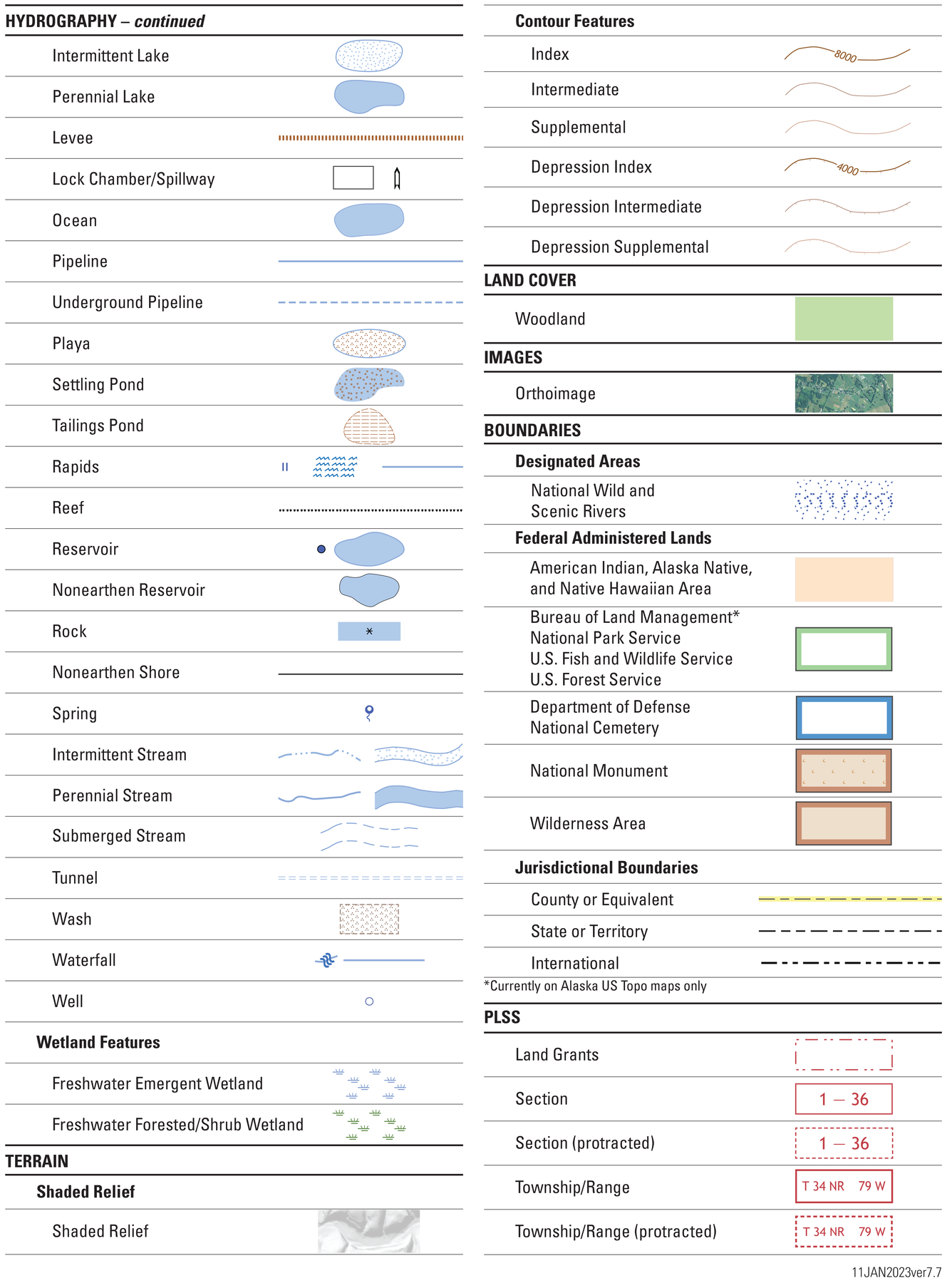
Symbols on US Topo maps
The underlying orthoimage for each US Topo map shows those features on the Earth’s surface that are visible to the eye. Because each map is made at a scale of 1:24,000 (one inch on the map represents 24,000 inches or 2,000 feet on the ground), selected features are also shown and emphasized by symbols, geographic names, and highway route numbers.
Map features may be represented as points, lines, or polygons. They incorporate different colors and patterns to distinguish between feature types and to show each feature’s importance. For example, a perennial stream is symbolized by a solid blue line while an intermittent stream is shown by a blue dashed and dotted line. A large reservoir is depicted by a polygon while a small reservoir may be shown by a point symbol if it is too small to show as a polygon.
Point symbols of different shapes and sizes depict features such as structures, dams, gates, rocks, waterfalls, and wells. Linear map symbols (lines) show such features as roads, rivers, boundaries, and contours. Color is used to show the class of information: topographic contours in brown, streams and rivers and other hydrographic features in blue, and roads in black and red. Areal features are outlined to depict the areal extent and may also be emphasized by a color tint. Names and labels are shown in different type fonts, sizes, and colors.
The unique feature of a topographic map is the contour. These lines do not exist on the Earth’s surface. They join points of equal elevation above a zero level surface (such as Mean Sea Level) and therefore show heights of the land and reveal the shape of the land surface. Heavier brown lines are index contours and are labeled with the elevation they represent. Closely spaced contours indicate a steep land slope; widely spaced contours show more level ground. The elevation difference between adjacent contours is the contour interval. A map of a relatively flat area may have a contour interval of 10 feet. In steep areas an interval of 100 feet or more may be used to avoid coalescence or convergence of the contour lines. The contour interval is always noted below the bar scale in the map marginalia.
The cartographic representation of roads has been updated from a characterization based on organizational maintenance (Interstates, US routes, State routes, etc.) to a functional classification defined as follows:
- Expressway¹: A controlled access, divided arterial highway for through traffic.
- Secondary Highway¹: Hard surface highways including secondary State routes, primary county routes, and other highways that connect principal cities and towns, and link these places with the primary highway system.
- Local Connector¹: Hard surface roads not included in a higher class and improved, loose surface roads passable in all kinds of weather. These roads are adjuncts to the primary and secondary highway system and represent major arteries through populated places.
- Local Road¹: Roads used primarily for local traffic.
- Four-Wheel Drive Road¹: Unimproved roads passable only with four-wheel drive vehicles.