



US Topo: Maps for America
topoBuilder
Create custom USGS topographic maps on demand using the best available data from The National Map
Explore Historical USGS Topographic Maps
The Historical Topographic Map Collection contains USGS topographic maps published from 1884 to 2006
Built on the success of over 140 years of USGS topographic mapping, the US Topo series delivers consistent map coverage of the American landscape using National Map data.
Get Topo Maps

Current US Topos and historical topographic maps are available as digital files or printed to order.
Create an OnDemand Topo
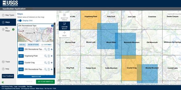
Build a USGS topographic map with choice of format, area of interest, scale, and National Map content.
Topographic Maps for the Nation
US Topo maps are produced by the National Geospatial Program of the U.S. Geological Survey (USGS). First launched in 2009, US Topos combine the familiar look and feel of legacy paper USGS topographic maps with technological advances of the 21st century.
US Topo map data is derived from the geographic information system (GIS) data of The National Map and is continuously updated via National, state, local, and commercial partnerships. Current and historic USGS topographic maps are available for immediate download from The National Map Downloader. Please note that not all features on historical maps appear on US Topos.
Characteristics Common to US Topo and Traditional USGS Topographic Maps
- Same extents as the popular 7.5-minute, 1:24,000-scale* quadrangle maps released 1947 - 2006 *scale varies in Alaska & Puerto Rico
- Standardized layout of map collar and traditional reference system (latitude/longitude & U.S. National Grid)
- Portrays both natural and built features within the themes of elevation, hydrography, geographic names, transportation, boundaries, structures, & land cover
Unique Characteristics of US Topo Maps

Content & Currency
- Consistent and complete coverage of the Nation, including Hawaii, Puerto Rico, the U.S. Virgin Islands, and Alaska (completed 2021)
- Check publish dates and access the latest US Topos using the US Topo Availability service
- Historically followed a 3-year production cycle for the 48 conterminous states, Hawaii, & Puerto Rico
- Shaded relief (from 3DEP elevation data where available) and high-resolution color imagery
- Georeferenced to the North American Datum of 1983 (NAD 83) or World Geodetic System of 1984 (WGS 84), projected in Universal Transverse Mercator (UTM)
- Continuous enrichment of map content and cartography
Usability & Accessibility
- Published as digital documents, enabling faster, wider distribution of products via free & immediate downloads
- Viewable and printable using Adobe Reader or other free PDF applications
- Geospatial PDF format enables basic GIS functionality, such as displaying coordinates, distance or area measurement, and georeferenced mark-up
- Layered PDF allows users to turn each data layer on or off to support a variety of map views and purposes
- Accompanied by a symbol guide and FGDC-compliant metadata