
Photo & Video Chronology — April 30, 2026 — Satellite imagery showing changes to Kīlauea summit region
By Hawaiian Volcano Observatory
April 30, 2026
Satellite images collected before and during the episodic lava fountaining eruption at the summit of Kīlauea show how the deposits from this eruption have changed the local landscape.
Media
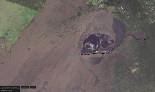
Satellite image of Halemaʻumaʻu and Kaluapele at Kīlauea summit in Hawaiʻi Volcanoes National Park. This image was taken on November 27, 2024, before the episodic lava fountaining eruption in Halemaʻumaʻu began on December 23, 2024. Different-colored lava flows on the floor of Halemaʻumaʻu, Kaluapele, and around the caldera are different ages. Image credit: WorldView ©2026 Maxar, USG Plus.
Sources/Usage: Public Domain. View Media Details
Media
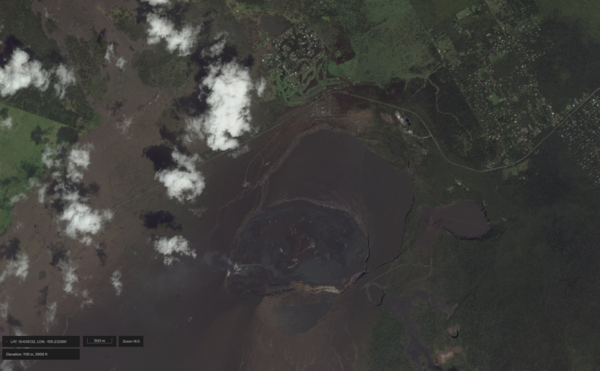
Satellite image of Halemaʻumaʻu and Kaluapele at Kīlauea summit in Hawaiʻi Volcanoes National Park. Two eruptive vents (named the north and south vents) in Halemaʻumaʻu have been erupting lava fountains episodically since December 23, 2024. Forty-five episodes have occurred to date, depositing tephra around and in Kaluapele, and lava flows within Halemaʻumaʻu. Dark brown tephra deposits are thickest to the southwest of Halemaʻumaʻu, but have been deposited on the caldera floor to the east and beyond. On the eastern caldera floor, the tephra deposits make it hard to distinguish between the different-colored lava flows that are different ages in this area. Image credit: WorldView ©2026 Maxar, USG Plus.
Sources/Usage: Public Domain. View Media Details
Media
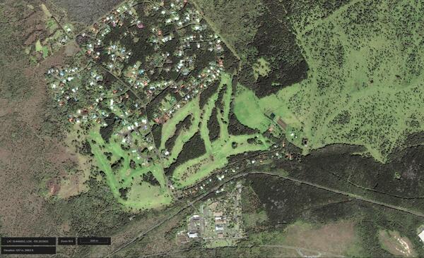
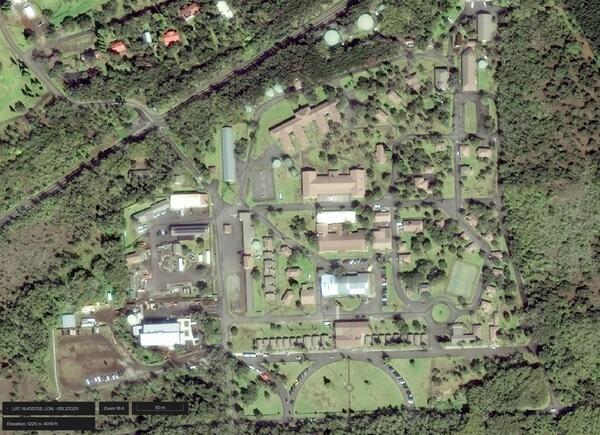
Satellite image of Kilauea Military Camp near Kīlauea summit in Hawaiʻi Volcanoes National Park and neighboring Volcano Golf Course subdivision taken on January 7, 2026, and showing green grass and vegetation surrounding infrastructure. Image credit: WorldView ©2026 Maxar, USG Plus.
Sources/Usage: Public Domain. View Media Details
Media
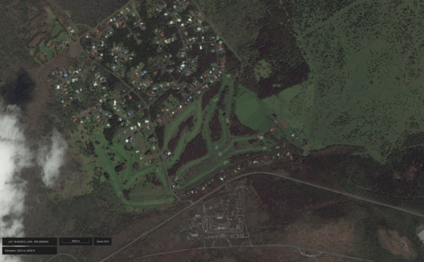
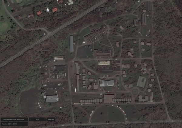
Satellite image of Kilauea Military Camp near Kīlauea summit in Hawaiʻi Volcanoes National Park and neighboring Volcano Golf Course subdivision taken on April 22, 2026, and showing tephra covering the ground and roofs. This area was affected by tephra deposition during lava fountaining episodes 43 (March 10, 2026) and 44 (April 9, 2026) at the summit of Kīlauea, in part due to wind conditions. Image credit: WorldView ©2026 Maxar, USG Plus.
Sources/Usage: Public Domain. View Media Details
Media
Satellite image of Kilauea Military Camp near Kīlauea summit in Hawaiʻi Volcanoes National Park taken on January 7 2026, and showing green grass and vegetation surrounding infrastructure. Image credit: WorldView ©2026 Maxar, USG Plus.
Sources/Usage: Public Domain. View Media Details
Media
Satellite image of Kilauea Military Camp near Kīlauea summit in Hawaiʻi Volcanoes National Park taken on April 22, 2026, and showing tephra covering the ground and roofs. This area was affected by tephra deposition during lava fountaining episodes 43 (March 10, 2026) and 44 (April 9, 2026) at the summit of Kīlauea, in part due to wind conditions. Image credit: WorldView ©2026 Maxar, USG Plus.
Sources/Usage: Public Domain. View Media Details
Media
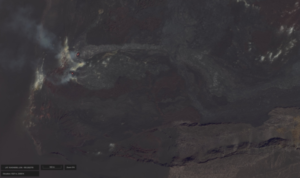
Satellite image of the north and south vents in Halemaʻumaʻu at the summit of Kīlauea on April 22, 2026. Incandescent lava is visible in both vents, and episode 45 of lava fountaining started shortly later during the early morning hours of April 23, 2026. Image credit: WorldView ©2026 Maxar, USG Plus.
Sources/Usage: Public Domain. View Media Details
Media
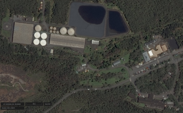
Satellite image of Volcano House Hotel (lower right in image), Kīlauea Visitor Center (middle right in image), and neighboring infrastructure near Kīlauea summit in Hawaiʻi Volcanoes National Park taken on April 22, 2026. This area was affected by tephra deposition during lava fountaining episodes 41 (January 24, 2026) and 43 (March 10, 2026) at the summit of Kīlauea, in part due to wind conditions. Image credit: WorldView ©2026 Maxar, USG Plus.
Sources/Usage: Public Domain. View Media Details
Media

Sources/Usage: Public Domain. View Media Details