
Photo & Video Chronology — June 6, 2025 — Kīlauea Episode 24
By Hawaiian Volcano Observatory
June 9, 2025
The ongoing Kīlauea summit eruption that began on December 23, 2024, is currently paused following the high fountaining of episode 24 for 7.5 hours on June 4-5, 2025.
Media
Sources/Usage: Public Domain. View Media Details
Media
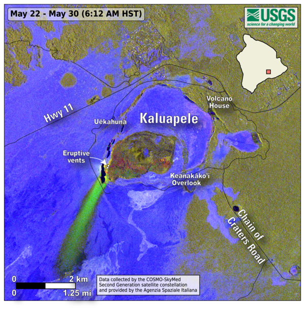
This map shows lava flow and tephra accumulation at Kīlauea volcano associated with episode 23 of the ongoing eruption in Halemaʻumaʻu that started on December 23, 2024. The image covers the timespan from May 22–30, 2025, using data recorded by the Italian Space Agency's (ASI) COSMO-SkyMed Second Generation satellite constellation. This map combines cross-polarized radar amplitude images taken on two different dates, along with interferometric coherence from the time between those dates. This approach enables the detection of volcanic mass flows (such as lava flows) and other tephra-fall deposits regardless of surface or weather conditions. In the map, unchanged barren areas are represented in blue/purple, vegetated areas appear in yellow/light green, and new deposits over barren land are shown in either dark or bright green. The bright green areas show the extent of lava flows in Halemaʻumaʻu and tephra that was deposited southwest of Halemaʻumaʻu during episode 23, when lava fountains were active for 6 hours on May 25. Tephra are volcanic fragments, such as Pele's Hair and scoria, that travel through the air before falling on the ground. Lava fountains during episode 23 reached up to 1150 ft (350 meters) and tephra was deposited over 2 miles (3.5 kilometers) from the vents in a south-southwest direction.
Sources/Usage: Public Domain. View Media Details
Media
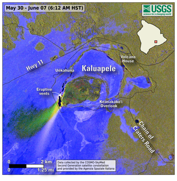
This map shows lava flow and tephra accumulation at Kīlauea volcano associated with episode 24 of the ongoing eruption in Halemaʻumaʻu that started on December 23, 2024. The image covers the timespan from May 30–June 7, 2025, using data recorded by the Italian Space Agency's (ASI) COSMO-SkyMed Second Generation satellite constellation. This map combines cross-polarized radar amplitude images taken on two different dates, along with interferometric coherence from the time between those dates. This approach enables the detection of volcanic mass flows (such as lava flows) and other tephra-fall deposits regardless of surface or weather conditions. In the map, unchanged barren areas are represented in blue/purple, vegetated areas appear in yellow/light green, and new deposits over barren land are shown in either dark or bright green. The bright green areas show the extent of lava flows in Halemaʻumaʻu and tephra that was deposited southwest of Halemaʻumaʻu during episode 24, when lava fountains were active for 7.5 hours on June 5-6. Tephra are volcanic fragments, such as Pele's Hair and scoria, that travel through the air before falling on the ground. Lava fountains during episode 24 reached up to 1200 ft (365 meters) and tephra was deposited nearly 2 miles (3 kilometers) from the vents. The white-ish streak to the south-southwest is the very reflective surface of the tephra deposits from episode 23.
Sources/Usage: Public Domain. View Media Details
Media

Sources/Usage: Public Domain. View Media Details