
Volcano Watch — Adapting to an evolving eruption: revising Kīlauea’s Alert Level and Aviation Color Code Notifications
The USGS Volcano Alert Level (ground-based hazards) and Aviation Color Code (airborne hazards) communicate Kīlauea status and activity. After episode 44, which is forecast to begin between April 6–14, the USGS Hawaiian Volcano Observatory (HVO) will change how it applies the Alert Level and Aviation Color Code to better convey hazards between and during eruptive episodes at Kīlauea summit.
Volcano Watch is a weekly article and activity update written by U.S. Geological Survey Hawaiian Volcano Observatory scientists and affiliates.
As this historic episodic Kīlauea summit lava fountaining eruption has continued, and its associated hazards have changed through time, HVO has also adjusted its messaging to better inform the aviation sector and communities on island who are affected by this activity.
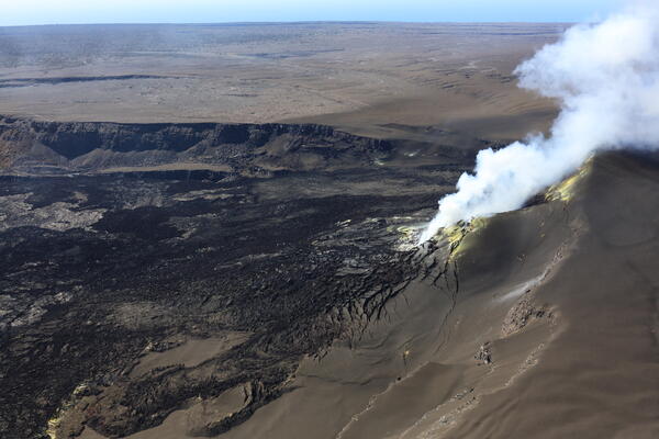
Now, more than a year into the eruption, the pauses between eruptive episodes that is the duration of time that the Kīlauea summit is not actively fountaining has lengthened. Initial episodes were as short as several days apart, while recent episodes have been separated by pauses lasting 3 weeks or longer.
With 43 episodes of observation, HVO has been able to characterize the hazards associated with lava fountaining, and areas affected by fallout vary depending on the wind conditions at the time. During the pauses, eruption-related hazards are greatly reduced compared to during eruptive episodes. The forecastable nature of these fountaining episodes allows HVO to move between Alert Levels/Aviation Color Codes with greater confidence than usually precedes the onset of a new eruption.
For most of the ongoing episodic lava fountaining eruption at the summit, Kīlauea Alert Level and Aviation Color Code have been at WATCH and ORANGE both during eruptive episodes and pauses. WATCH (ground hazards) indicates that a volcano is exhibiting escalating unrest or that an eruption is underway but poses limited hazards, while ORANGE (aviation hazards) indicates an eruption is underway with no or minimal ash emissions (or that there is heightened or escalating unrest with increased potential for an eruption).
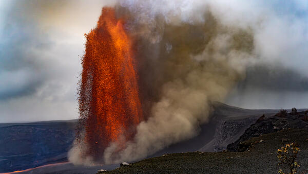
Kīlauea Alert Level and Aviation Color Code were raised to WARNING and RED during episode 43 on March 10, indicating that a volcanic eruption was under way creating hazardous conditions on the ground and with significant emission of volcanic ash into the atmosphere.
The NOAA Washington Volcanic Ash Advisory Center, which monitors and characterizes movement of airborne volcanic ash clouds in the region, reported that the volcanic cloud produced by lava fountaining during episode 43 reached over 22,000 feet (6,700 meters) above sea level. The plume travelled to the northeast, with fallout causing closures in Hawaiʻi Volcanoes National Park and along Highway 11. Ash fell over much of the District of Puna and parts of North and South Hilo. The National Weather Service issued an Ashfall Advisory and Warning, and there were flight cancelations at the Hilo International Airport.
Following the end of episode 43, the Alert Level and Aviation Color Code were lowered back down to WATCH and ORANGE. After episode 44 ends, assuming activity is similar to the first 43 episodes, HVO will lower the Alert Level and Aviation Color Code for Kīlauea one level lower, to ADVISORY and YELLOW. When decreasing from a higher level, ADVISORY and YELLOW indicate that volcanic activity has decreased significantly but continues to be closely monitored for possible renewed increase. This Alert Level and Aviation Color Code more appropriately convey the level of activity and associated ground and airborne hazards at Kīlauea during eruptive pauses.
Assigning Kīlauea an Alert Level and Aviation Color Code of ADVISORY and YELLOW during eruptive pauses also means that when a new episode approaches or begins, HVO can then raise the Alert Level and Aviation Color Code to WATCH and ORANGE to better reflect that the volcano is showing escalating unrest or that an eruption is underway with limited hazards and only minor ash emissions. If a significant plume is generated and there are hazardous conditions on the ground, such as what occurred during episode 43, HVO will raise the Kīlauea Alert Level and Aviation Color Code to WARNING and RED.
We appreciate the patience shown by residents and partners as we continue to adjust messaging to best communicate activity and hazards during Kīlauea’s lava fountaining eruption. You can subscribe to receive notifications from the Volcano Alert Level and Aviation Color Code System using the Volcano Notification Service (https://volcanoes.usgs.gov/vns/).
Volcano Activity Updates
Kīlauea has been erupting episodically within the summit caldera since December 23, 2024. Its USGS Volcano Alert level is WATCH.
Episode 43 of summit lava fountaining happened for 9 hours on March 10. Summit region inflation since the end of episode 43 indicates that another fountaining episode is possible; models suggest that episode 44 could begin between April 6-14. No unusual activity has been noted along Kīlauea’s East Rift Zone or Southwest Rift Zone.
Mauna Loa is not erupting. Its USGS Volcano Alert Level is at NORMAL.
Three earthquakes were reported felt in the Hawaiian Islands during the past week: a M2.5 earthquake 4 km (2 mi) SW of Honoka‘a at 7 km (4 mi) depth on March 28 at 9:58 a.m. HST, a M3.0 earthquake 10 km (6 mi) S of Pa‘auilo at 10 km (6 mi) depth on March 26 at 9:16 p.m. HST, and a M3.1 earthquake 5 km (3 mi) SSE of Pa‘auilo at 9 km (5 mi) depth on March 26 at 4:22 p.m. HST.
HVO continues to closely monitor Kīlauea and Mauna Loa.
Please visit HVO’s website for past Volcano Watch articles, Kīlauea and Mauna Loa updates, volcano photos, maps, recent earthquake information, and more. Email questions to askHVO@usgs.gov.