
Volcano Watch — Mauna Loa has lessons to teach during quiet times
The 2022 eruption of Mauna Loa was an extraordinary eruption in a lot of ways. It was the first eruption from this volcano in 38 years and the first Mauna Loa eruption that occurred during the current era of modern instrumentation. Scientists continue to learn about Mauna Loa monitoring in the years since the 2022 eruption, including subtle recent changes.
Volcano Watch is a weekly article and activity update written by U.S. Geological Survey Hawaiian Volcano Observatory scientists and affiliates. Today’s article is by HVO research geophysicist Ingrid Johanson.
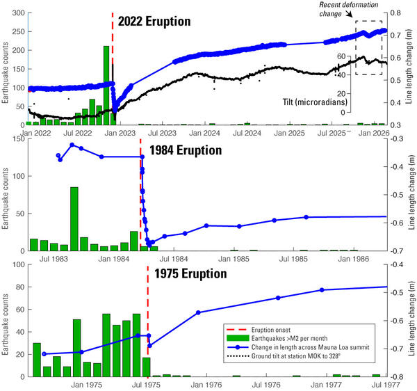
The long-term buildup to the 2022 eruption began in 2014, with an increase in seismicity and deformation as measured by the USGS Hawaiian Volcano Observatory’s (HVO) network of GPS stations. These indictors fluctuated until 2019, when they began to increase again. In 2021, we observed changes on a Mauna Loa tiltmeter representing the first time a volcanic signal had been recorded on that instrument. As explained in a "Volcano Watch" article on May 6, 2021, tiltmeters are particularly sensitive to shallow magma movement. This was evidence that magma had reached a shallow depth in 2021 and was an important indicator that the buildup to eruption was evolving.
The 2022 eruption began just before midnight on November 27, preceded by an hour‑long earthquake swarm and rapid summit inflation. It started in the summit region before moving into Mauna Loa’s Northeast Rift Zone. There, multiple fissures produced lava flows that erupted downslope towards the Daniel K. Inouye Highway. During the eruption, seismicity quieted down and deformation indicated rapid deflation of Mauna Loa’s magma chambers. By December 13, 2022, the lava flows had slowed and the eruption had stopped.
Following the end of the eruption, GPS instruments quickly began to show inflationary motion again, presumably as magma rose from deeper in the volcano into the magma chambers that had been depleted during the eruption. This rapid refilling continued for about six months before settling into a steadier reinflation pattern.
Recently, changes to the reinflation pattern have given us some clues to the current state of the volcano. In November 2025, the deformation pattern around Mauna Loa’s summit changed. Where previous motions indicated reinflation of magma chamber underneath Moku'āweoweo (summit caldera), inflation shifted to a body underneath the southwestern portion of the summit region.
This was not the first time this pattern had been observed. In 2015, the deformation pattern seen with GPS shifted in a similar way. Inflation of the southwestern magma chamber continued until late 2016, before switching back to the more central body under Moku'āweoweo. This time, deformation switched back much faster; by December 15, 2025, the inflation center was again under the summit caldera.
Interestingly, the 2025 deformation changes seen with GPS were also accompanied by clear changes in tilt at a summit tiltmeter. This was not the case in 2015, when only GPS stations recorded volcanic deformation. The fact that this deformation is detectable on tiltmeters is an indication that magma is still fairly shallow in the volcano (geologically speaking), possibly between 2-3 km below the surface (1.25–1.8 miles).
However, currently there is less seismicity at Mauna Loa than at almost any time during the eight years of unrest before the 2022 eruption. This means that the deformation we’re seeing is likely passive refilling in the volcano that isn’t stressing the crust in a way that would indicate the volcano is moving towards eruption.
This pattern was observed following the 1975 and 1984 Mauna Loa eruptions as well. Rapid inflationary deformation was recorded without much seismicity. It wasn’t until earthquakes started again that the volcano clearly began moving toward its next eruption.
The tilt and GPS observations are nonetheless a reminder that Mauna Loa is in a different state now than it was before the 2022 eruption. The tilt changes provide evidence that magma is still mobile in Mauna Loa, which is an important factor in how unrest might progress in the future. The build up to the next eruption might not look the same as the buildup to 2022. Especially if Mauna Loa returns to producing eruptions more frequently than decades apart, as it did prior to 1984.
The alert level for Mauna Loa is currently “normal”; we expect to see additional changes such as increased seismicity or gas emissions before any future eruption. Even during quiet times, keeping a close eye on the volcanoes can teach important lessons that will inform our interpretations and decisions as the conditions change.
Volcano Activity Updates
Kīlauea has been erupting episodically within the summit caldera since December 23, 2024. Its USGS Volcano Alert level is WATCH.
Episode 42 lava fountaining happened for just under 10 hours on February 15. Summit region inflation since the end of episode 42 indicates that another fountaining episode is possible. Preliminary models suggest episode 43 could occur between March 6 and 16. No unusual activity has been noted along Kīlauea’s East Rift Zone or Southwest Rift Zone.
Mauna Loa is not erupting. Its USGS Volcano Alert Level is at NORMAL.
Three earthquakes were reported felt in the Hawaiian Islands during the past week: a M3.2 earthquake 10 km (6 mi) WSW of Pāhala at 0 km (0 mi) depth on Feb. 25 at 8:52 p.m. HST, a M3.6 earthquake 24 km (14 mi) WSW of Kahaluu-Keauhou at 38 km (24 mi) depth on Feb. 24 at 2:25 a.m. HST, and a M4.1 earthquake 46 km (28 mi) SW of Kekaha at 11 km (7 mi) depth on Feb. 22 at 8:25 a.m. HST.
HVO continues to closely monitor Kīlauea and Mauna Loa.
Please visit HVO’s website for past Volcano Watch articles, Kīlauea and Mauna Loa updates, volcano photos, maps, recent earthquake information, and more. Email questions to askHVO@usgs.gov.