



Volcano Watch — September is National Preparedness Month
Benjamin Franklin said, “If you fail to prepare, you are preparing to fail.” As the past year in Hawaii has shown, hurricanes, eruptions, earthquakes, flooding, and severe weather can occur with little or no warning and result in power outages, disrupted roadways, and other impacts. Steps you take to prepare in advance for any one emergency can help you and your family be better prepared overall.
Volcano Watch is a weekly article and activity update written by U.S. Geological Survey Hawaiian Volcano Observatory scientists and affiliates. Today's article is by HVO geologist Katie Mulliken.
Four steps that you can take to be better prepared for any disaster include: learning what hazards can affect you and when, making an emergency plan, building an emergency supply kit (go bag), and getting involved in your community.
Unlike hurricanes, earthquakes and volcanic eruptions in Hawaii do not have a season and can occur at any time. The earthquake hazard in the State of Hawaii is among the highest in the United States, with the south side of the Island of Hawai‘i having the highest hazard. Earthquakes in Hawaii can have far-reaching impacts, and result in ground cracks, ground settling, landslides, and local tsunami.
While earthquakes can strike unexpectedly at any time, eruptions are often preceded by signs of unrest. USGS Hawaiian Volcano Observatory (HVO) scientists closely monitor active volcanoes in Hawaii for any signs of unrest and communicate via the USGS Volcano Alert Level and Aviation Color Code.
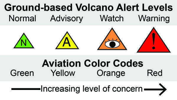
The Volcano Alert Level is a series of words—NORMAL, ADVISORY, WATCH, WARNING—that describe activity and associated hazards to people on the ground. A volcano at Alert Level NORMAL is not erupting or showing signs of unrest (earthquakes/ground deformation/gas emissions) while a volcano at Alert Level WARNING is erupting in a hazardous way (or about to).
The Aviation Color Code System is a series of colors—GREEN, YELLOW, ORANGE, RED—to inform the aviation sector about airborne ash hazards. A volcano at Color Code GREEN is not erupting or showing signs of unrest while a volcano at Color Code RED is erupting and generating significant volcano ash emissions into the atmosphere (or about to).
Usually, the Volcano Alert Level and Aviation Color Code are paired and move together, but they may occasionally be de-coupled when the hazards on the ground and in the air are very different. For example, if lava flows were threatening infrastructure, the ground-based Volcano Alert Level may be at the highest level, WARNING, but the Aviation Color Code may not be at the highest level of RED because of the lack of significant airborne ash emissions.
If you live in Hawaii, consider learning which active volcano(s) encompass the areas where you live and work. Areas that can be hazardous during a volcanic eruption include those immediately around the erupting volcanic vent, areas downwind of the vent if the eruption produces ash and significant volcanic gas emissions, and areas downslope of the vent if the eruption produces lava flows.
When putting together an emergency plan, consider signing up to receive notifications from HVO via the Volcano Notification Service (VNS) as well as messaging from other relevant authoritative organizations such as the County of Hawaii Civil Defense Agency. The Federal Emergency Management Agency (FEMA) ready.gov website has resources on preparing an emergency plan for your household, which should also consider evacuations and communication channels: https://www.ready.gov/plan.
The State of Hawaii is isolated in the middle of the Pacific Ocean, and many communities across the Hawaiian Islands are rural. This means that when disaster strikes, the arrival of aid can take time. Building an emergency supply kit can ensure that during or after hazardous events, you and your family can be temporarily self-sufficient if needed. FEMA’s website also provides an emergency supply checklist to get you started but be sure to consider the unique needs of your family, such as pets supplies: https://www.ready.gov/kit.
The last step in preparation is to get involved in your community. Because Hawaii’s communities are so isolated, the first response to a hazardous event often falls on the shoulders of the community affected. Practice and socialize your plan with family and friends in your community. This will familiarize yourself with your plan and encourage others in your community to also prepare.
Local resources, including information for businesses and additional checklists, are available from Hawaii County Civil Defense and Hawaiʻi Emergency Management Agency. Additional preparedness resources are available through FEMA at https://www.ready.gov/stand-ready.
Volcano Activity Updates
Kīlauea has been erupting episodically within the summit caldera since December 23, 2024. Its USGS Volcano Alert level is ADVISORY.
Episode 54 of lava fountaining at the summit occurred on August 25 for 9 hours. Summit region inflation has been very irregular following episode 54; current forecast models indicate that episode 55 could occur between September 7-12 but this window is subject to change as more monitoring data is collected. No unusual activity has been noted along Kīlauea’s East Rift Zone or Southwest Rift Zone.
Mauna Loa is not erupting. Its USGS Volcano Alert Level is at NORMAL.
No earthquakes were reported felt in the Hawaiian Islands during the past week.
HVO continues to closely monitor Kīlauea and Mauna Loa.
Please visit HVO’s website for past Volcano Watch articles, Kīlauea and Mauna Loa updates, volcano photos, maps, recent earthquake information, and more. Email questions to askHVO@usgs.gov.