
Volcano Watch — Think Hawaii has many volcanoes? Think again, says El Salvador
This past March, a team of U.S. Geological Survey (USGS) scientists—two of whom travelled from Hawaii—visited El Salvador in Central America for volcanological field studies and a workshop on lava flow hazards. Exchanges like this help to improve awareness of volcanic hazards in other countries, and they enable the USGS to better understand volcanoes in our own backyard.
Volcano Watch is a weekly article and activity update written by U.S. Geological Survey Hawaiian Volcano Observatory scientists and affiliates.
El Salvador is the smallest country in Central America, sitting on the Pacific coast and measuring slightly larger than all the Hawaiian Islands combined.
However, the eight main Hawaiian Islands are comprised of only 15 volcanoes above sea level; El Salvador, on the other hand, has over 200! And that’s with a population of about 6 million people, about four times as many as Hawaii.
There are numerous volcanoes in El Salvador because it sits along the Central American volcanic arc, rather than atop a hotspot like Hawaii. Volcanic arcs form where an oceanic tectonic plate subducts beneath either a continental plate or another oceanic one; the ocean crust triggers melting as it dips into the Earth's mantle, creating magma that rises to the surface through the overlying plate. Though El Salvador has five larger volcanoes with historical eruptions, numerous fault lines allow magma from the subduction zone to emerge just about anywhere. This has resulted in hundreds of smaller volcanoes, most of which have erupted only once.
Volcano monitoring in El Salvador is handled by the Ministerio de Medio Ambiente y Recursos Naturales (MARN). In addition to tracking the weather and other natural hazards, a small team of volcanologists works to study the geological and geophysical dynamics of the country’s volcanoes, while maintaining a watchful eye for signs of unrest. The stratovolcanoes of Santa Ana and San Miguel have both erupted in the past 25 years, but even more destructive events have occurred in the not-too-distant past: San Salvador volcano sent a lava flow into presently developed areas in 1917, and Ilopango caldera had a regionally devastating eruption in the year 431.
USGS, through its Volcano Disaster Assistance Program (VDAP), has maintained a collaborative relationship with MARN for decades. Co-funded by the U.S. Department of State, VDAP has supported numerous technical investigations and monitoring projects at volcanoes in developing countries around the world. Meanwhile, many MARN volcanologists have even studied in the United States as part of the Center for the Study of Active Volcanoes (CSAV) course held every summer in Hawaii and Washington state.
In recent years, VDAP’s relationships in El Salvador have focused on geologic projects to describe the eruptive history and hazards of Santa Ana volcano and a broader effort to assemble a national “volcano atlas,” which will include locations, compositions, and—hopefully—approximate ages for the more than 200 volcanic vents in the country. Such knowledge will enable more accurate understanding and delineation of hazards associated with their eruptions, which are both explosive (ash-producing) and effusive (lava flow-producing).
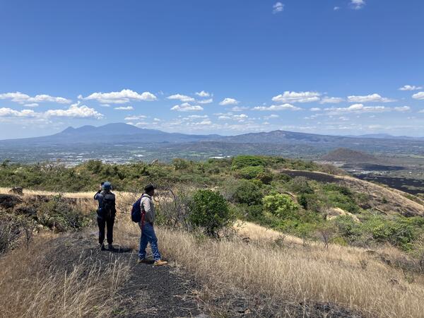
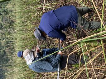
The field work in March served both projects. Dozens of samples were collected to correlate and date eruptive deposits across Santa Ana, including three sediment cores from coastal mangroves and a montane bog that may contain distant ashfall from the volcano. Reconnaissance visits were also made to several monogenetic (single-eruption) vents scattered around western El Salvador to assess their genesis and ages.
Finally, VDAP sponsored a week-long workshop on lava flow hazards and monitoring for MARN staff and partner agencies. Since El Salvador’s last lava flow erupted in 1917, none of the current team have responded to such an event. USGS scientists from the Hawaiian, Cascades, and Alaska Volcano Observatories discussed their experiences and best practices developed during recent eruptions at Kīlauea and Mauna Loa in Hawaii, as well as Great Sitkin and Pavlof in Alaska.
While the USGS scientists learned plenty about volcanism in El Salvador during this trip, it also provided key insights to bring home to our own volcanoes. Explosive eruptions in Hawaii are relatively rare, but the ability to correctly interpret their deposits is critical to understanding potential future hazards. Additionally, the more distributed nature of volcanoes in El Salvador has led to interesting interactions between lava flows and their more-weathered depositional environments, not unlike some of Hawaii’s older volcanoes: Hualālai, Mauna Kea, and Haleakalā. We thank MARN for the opportunity to visit and study their country’s volcanoes.
Volcano Activity Updates
Kīlauea has been erupting episodically within the summit caldera since December 23, 2024. Its USGS Volcano Alert level is ADVISORY.
Episode 46 of summit lava fountaining happened for 9 hours on May 5. Summit region inflation since the end of episode 46 indicates that another fountaining episode is possible but more time and data is needed before a forecast can be made. No unusual activity has been noted along Kīlauea’s East Rift Zone or Southwest Rift Zone.
Mauna Loa is not erupting. Its USGS Volcano Alert Level is at NORMAL.
No earthquakes were reported felt in the Hawaiian Islands during the past week.
HVO continues to closely monitor Kīlauea and Mauna Loa.
Please visit HVO’s website for past Volcano Watch articles, Kīlauea and Mauna Loa updates, volcano photos, maps, recent earthquake information, and more. Email questions to askHVO@usgs.gov.