



Volcano Watch — Using ocean noise to monitor for volcanic eruptions
Ocean swells are constantly beating on the ocean floor. This nonstop drumming creates continuous signals that travel through the Earth and are recorded on seismometers. Changes in the speed of these ocean noise signals can give us clues about volcanic activity.
Volcano Watch is a weekly article and activity update written by U.S. Geological Survey Hawaiian Volcano Observatory scientists and affiliates.
Ocean noise signals are recorded on seismometers all over the world, including here in Hawaii. Most of the time, we don’t look at this noise…paying attention instead to the seismic signals being generated within a volcano. By using a technique called ambient noise interferometry to look at the ocean noise in seismic data, we can see that these signals slow down or speed up when traveling through the volcano. But why is it important that we identify such changes in speed?
Here at the USGS Hawaiian Volcano Observatory, we are most interested in understanding when and where a volcanic eruption will occur. Such speedups and slowdowns in ocean noise signals can be due to a variety of physical changes beneath the surface of a volcano, including changes that could be related to potential eruptive activity.
As magma travels to the surface before an eruption, it pushes on the rocks around it. The overlying rocks react to this pushing by breaking open, forming fractures and cracks beneath the ground surface. The presence of these cracks and fractures causes ocean noise signals to travel slower through this region.
Along the rim of a volcano’s caldera, existing fractures and cracks experience the opposite effect as magma accumulates in shallow storage chambers before an eruption. As magma moves upwards, it pushes outwards towards the caldera rim causing existing fractures and cracks to close. This decrease in the number of cracks along the caldera rim allows ocean noise signals to travel more rapidly through this region.
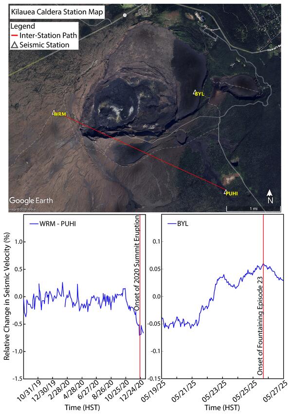
We use data recorded at seismometers across Kīlauea to monitor for such changes in the velocity of ocean noise signals. For example, we determined changes in velocity for the volume of crust between seismic stations WRM and PUHI—which are located on opposite sides of Kaluapele (Kīlauea summit caldera)—before the 2020 Kīlauea summit eruption.
Beginning two months before the 2020 eruption, the velocity of ocean noise seismic signals decreased, becoming the slowest right before the eruption began. The path between PUHI and WRM extends across the top of the shallow magma reservoir at Kīlauea summit, below Halemaʻumaʻu crater. As magma migrates to the surface before the start of an eruption, the opening of cracks and fractures causes the velocity of the ocean noise signals to decrease. We interpret this observed decrease in velocity in the Kīlauea summit region to be indicative of magma shallowing.
We can similarly analyze velocity changes in ocean noise at seismometers across Kīlauea to look for clues suggesting the start of new lava fountaining episodes during the ongoing summit eruption. To forecast the start of the fountaining episodes, we have focused on velocity changes occurring at seismic stations along Kīlauea’s caldera rim. In this case, as discussed earlier, we are looking for increases in velocity at these stations indicative of crack closure due to magma accumulated within the storage chamber beneath Halemaʻumaʻu. As such, we observed increases in velocity of ocean noise at caldera rim station BYL in the four days before the onset of fountaining episode 23 on May 25, 2025.
While the ambient noise interferometry technique is still being tested and evaluated with every new fountaining episode, scientists at the USGS Hawaiian Volcano Observatory see promising results. Looking at ocean noise could be another useful tool for forecasting when eruptive activity will begin at Kīlauea volcano.
Volcano Activity Updates
Kīlauea has been erupting episodically within the summit caldera since December 23, 2024. Its USGS Volcano Alert level is ADVISORY.
Episode 53 of the summit eruption lasted for 9.6 hours on August 12–13, with a lava fountain from the north vent reaching up to about 500 feet (150 meters). Summit region inflation since the end of episode 53 indicates that another fountaining episode is likely, but more data are needed to make a forecast. No unusual activity has been noted along Kīlauea’s East Rift Zone or Southwest Rift Zone.
Mauna Loa is not erupting. Its USGS Volcano Alert Level is at NORMAL.
Two earthquakes were reported felt in the Hawaiian Islands during the past week: a M3.1 earthquake 43 km (26 mi) SE of Nāʻālehu at 9 km (5 mi) depth on August 9 at 7:13 p.m. HST and a M5.2 earthquake 42 km (26 mi) ESE of Nāʻālehu at 10 km (6 mi) depth on August 11 at 5:48 p.m. HST.
HVO continues to closely monitor Kīlauea and Mauna Loa.
Please visit HVO’s website for past Volcano Watch articles, Kīlauea and Mauna Loa updates, volcano photos, maps, recent earthquake information, and more. Email questions to askHVO@usgs.gov.