



Volcano Watch — What caused the shake up on Friday night?
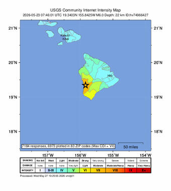
More than 7,000 people across the State of Hawaii submitted “Did You Feel It?” (DYFI) reports to the U.S. Geological Survey (USGS) after the magnitude-6 earthquake that struck on Friday, May 22, at 9:46 p.m. HST. What caused this earthquake and how did responding agencies message about it?
Volcano Watch is a weekly article and activity update written by U.S. Geological Survey Hawaiian Volcano Observatory scientists and affiliates.
The magnitude-6 earthquake happened at a depth of 14 miles (22 km) below sea level just south of Hōnaunau-Nāpōʻopoʻo on the west side of the Island of Hawaiʻi. The epicenter of the earthquake appeared to be on Mauna Loa when looking at a map. However, the base of Mauna Loa volcano sitting on top of the old oceanic crust is only 6 miles (10 km) below sea level. The earthquake occurred deeper than the volcano, even deeper than the base of the ocean crust, that is bent downward by the weight of the Hawaiian Island chain. These plate bending, or lithospheric flexure earthquakes occur within the upper lithospheric mantle within the Pacific Plate and are not directly related to volcanic activity.
The Pacific Plate is constantly re-adjusting to the weight of the islands through countless micro-earthquakes that no one ever feels. Bending of the plate generates larger, widely felt, and often damaging earthquakes that can occur from Hawai‘i Island to Molokai‘i. These larger earthquakes are widely felt because they are deep (12-30 miles or 20-50 km) and the lithospheric mantle efficiently transfers the earthquake waves.
Prior to the May 22nd earthquake, the most recent earthquakes larger than a magnitude 6 that were also caused by Pacific Plate adjustments were a magnitude-6.2 south of the Island of Hawaiʻi in 2021 with about 3,500 felt reports and the damaging magnitude-6.7 Kīholo Bay earthquake in 2006 with about 3,000 felt reports. The recent magnitude-6 on May 22 has set a new record for the State of Hawaii, for having the most DYFI reports and even included a felt report from Niʻihau. These reports are used to generate maps showing the intensity of shaking, which are very helpful for emergency management agencies that have to send personnel and resources to respond to damage reports, such as Hawaiʻi County Civil Defense Agency.
A few seconds after the earthquake started shaking the west side of the island, some Android phone users reported receiving alert notifications on their mobile devices: those that were near the epicenter received notifications that an earthquake had occurred near them, and those that were farther away from the epicenter might have received a notification of an earthquake nearby and to expect shaking. These messages rely on the accelerometer and location of your phone, as well as accelerometers and locations of other Android cell phones; adjusting your phone settings can enable you to turn those notifications on or off. The Android Earthquake Alerts System is a proprietary feature developed by Google and is active across the U.S. for earthquakes of magnitude 4.5 or greater, and differs from the USGS ShakeAlert Earthquake Early Warning System that is currently only available in some states (California, Oregon, and Washington).
While the messages sent by your phone arrive quickly because they rely on the shaking detected by thousands of Android cell phone users, the official messages sent by the USGS and Pacific Tsunami Warning Center can take minutes or longer because they rely on instrumentation located across the landscape. In some cases, humans need to verify the accuracy of the earthquake location and magnitude before a message is sent to ensure the release of accurate earthquake and tsunami information.
Nationally and globally, regional seismic networks compute the origin time and location for any given earthquake—to avoid confusion, only one set of earthquake information can be considered official. For the State of Hawaii, the authoritative regional seismic network is the USGS Hawaiian Volcano Observatory (HVO); for tsunami information and guidance, the NOAA Pacific Tsunami Warning Center is the authoritative agency.
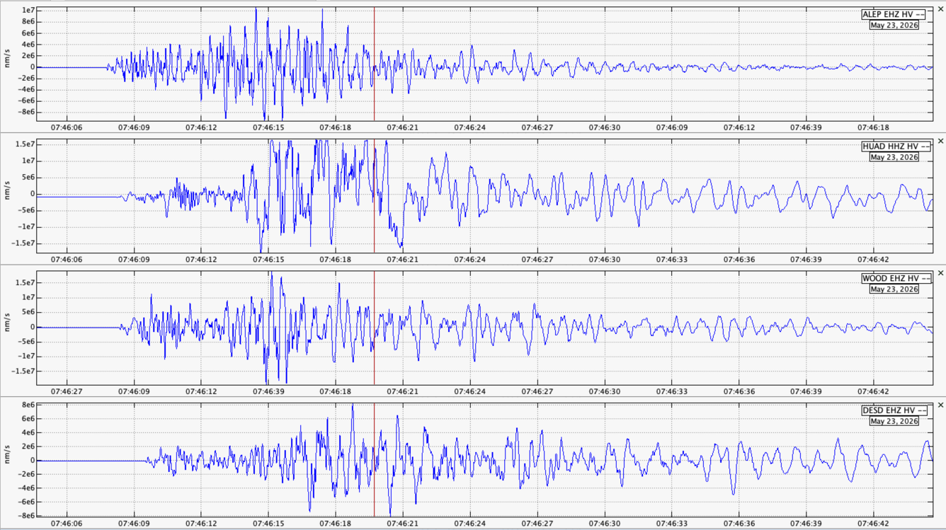
In the case of the May 22nd earthquake, staff at HVO started analyzing the earthquake data even before shaking had stopped, as the earthquake rolled through the south and east side of the Island of Hawaiʻi, HVO’s automated software system rapidly sent out preliminary estimates of the earthquake origin time, location and magnitude. HVO staff posted immediately to the HVO website and USGSVolcanoes social media accounts, acknowledging the earthquake had occurred and staff were analyzing the data. An initial earthquake message was sent to subscribers of the Earthquake Notification Service using a preliminary and automatically determined earthquake magnitude, location, and depth. Shortly after, the Pacific Tsunami Warning Center issued a statement that a tsunami had not been generated, after their analysts verified this by reviewing earthquake, tide gauge, and buoy data.
Within a few minutes after the earthquake, HVO released the reviewed earthquake timing, magnitude, location, and depth. Initially estimated as a magnitude-5.9 at 10 miles (16 km) depth, analysts determined the earthquake was larger and deeper, and revised it to a magnitude-6 at 14 miles (22 km) depth. With accurate knowledge of the earthquake parameters, HVO released an Information Statement via the Volcano Notification Service, which included the interpretation that the earthquake was related to Pacific Plate flexure and not related to magma movement within Mauna Loa.
The May 22 earthquake is a reminder that Hawaii is one of the most seismically active locations in the United States. Earthquakes can affect large areas and happen with no warning. During any earthquake, don’t forget to “Drop, Cover, and Hold On” and, if you are near the coast, immediately move inland in case a tsunami is generated.
Volcano Activity Updates
Kīlauea has been erupting episodically within the summit caldera since December 23, 2024. Its USGS Volcano Alert level is ADVISORY.
Episode 47 of summit lava fountaining happened for 9 hours on May 14-15. Summit region inflation since the end of episode 47 indicates that another fountaining episode is possible. Models currently indicate that episode 48 is most likely to begin between May 28 and May 30. No unusual activity has been noted along Kīlauea’s East Rift Zone or Southwest Rift Zone.
Mauna Loa is not erupting. Its USGS Volcano Alert Level is at NORMAL.
10 earthquakes were reported felt in the Hawaiian Islands during the past week: a M3.2 earthquake 0 km (0 mi) SSE of Hōlualoa at 37 km (23 mi) depth on May 23 at 7:25 a.m. HST, a M2.9 earthquake 8 km (4 mi) S of Honaunau-Napoopoo at 12 km (8 mi) depth on May 23 at 2:41 a.m. HST, a M4.0 earthquake 12 km (7 mi) S of Honaunau-Napoopoo at 23 km (14 mi) depth on May 23 at 12:56 a.m. HST, a M2.4 earthquake 10 km (6 mi) SSE of Honaunau-Napoopoo at 21 km (13 mi) depth on May 23 at 12:02 a.m. HST, a M2.6 earthquake 10 km (6 mi) S of Honaunau-Napoopoo at 16 km (10 mi) depth on May 22 at 10:50 p.m. HST, a M2.1 earthquake 15 km (9 mi) S of Honaunau-Napoopoo at 21 km (13 mi) depth on May 22 at 10:22 p.m. HST, a M2.3 earthquake 14 km (8 mi) SSE of Honaunau-Napoopoo at 4 km (2 mi) depth on May 22 at 10:01 p.m. HST, a M3.2 earthquake 10 km (6 mi) S of Honaunau-Napoopoo at 21 km (13 mi) depth on May 22 at 9:52 p.m. HST, a M6.0 earthquake 13 km (8 mi) S of Honaunau-Napoopoo at 22 km (14 mi) depth on May 22 at 9:46 p.m. HST, and a M1.8 earthquake 12 km (7 mi) NE of Pāhala at 31 km (19 mi) depth on May 22 at 1:49 p.m. HST.
HVO continues to closely monitor Kīlauea and Mauna Loa.
Please visit HVO’s website for past Volcano Watch articles, Kīlauea and Mauna Loa updates, volcano photos, maps, recent earthquake information, and more. Email questions to askHVO@usgs.gov.