
Best Student Geologic Map Competition at the Geological Society of America (GSA) Connects Annual Meeting
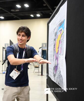
Each year, the USGS runs a poster session at the Geological Society of America (GSA) Connects Annual Meeting in which participants present their geologic mapping work. The top three student-authored geologic maps receive awards and recognition at a ceremony sponsored by GSA, GSA Foundation, Association of American State Geologists, American Institute of Professional Geologists, American Geosciences Institute, and Journal of Maps.
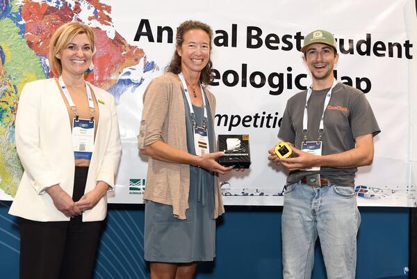
The map competition recognizes student geologic map makers, their accomplishments, and their important role in the future of geoscience, by providing them an opportunity to showcase their geologic maps and network with sponsors and attendees. Judges score each participating student’s map poster during the live presentation session, and the students with the top three best geologic maps are awarded with a sponsored prize during the Awards Ceremony afterwards.
The National Cooperative Geologic Mapping Program is now calling for abstracts from all student geologic mappers to present their maps at the 2026 Best Student Geologic Map Competition, which will take place at the GSA Connects Meeting in Denver, CO from October 11 to 14.
Abstracts must be submitted to the GSA Connects website no later than August 6.
The exact date and time of the competition are still TBD; more details about the competition will be posted here as soon as they are available. Please review the instructions and information below to prepare and submit your abstract! Some general information about the competition is summarized below.
TO PARTICIPATE
- Visit the GSA Connects website.
- Follow the links and instructions to “Submit an Abstract” before the submission deadline. The abstract submission window typically opens around early May and closes around early August.
- When submitting your abstract, search and select “Best Student Geologic Map Competition” from the list of Topical Sessions to make sure your submission is routed correctly.
- Register to attend GSA Connects and make your travel arrangements. Travel and registration information can also be found on the GSA Connects website.
- Bring your poster and present during the live poster session.
- Attend the awards ceremony to find out if you won a prize!
ELIGIBILITY
The Best Student Geologic Map Competition (BSGMC) at GSA Connects is not limited to only EDMAP participants but is open to ALL students who wish to present their geologic map poster, as defined below:
- The BSGMC defines a geologic map as a map that depicts the geographic distribution at the earth’s surface of bedrock and/or surficial geologic materials and structures, on a published base-map showing topography, hydrography, culture, cadastral, and other base information.
- Geologic units are identified by color and(or) map unit symbols, which correlate to the description of map units.
- Geologic structures are shown with symbols that allow the user to visualize the features in three-dimensional orientations.
- Geologic maps should be at scales ranging from 1:10,000 to 1:250,000.
- Data-synthesis geologic maps derived from geophysical data collected by students in the field are eligible!
- Examples of map types that are not eligible for judging and scoring in the BSGMC:
- Reconnaissance geologic maps
- Isopach or bedrock elevation maps
- Standalone stratigraphic or facies diagrams
- Gravity or magnetic anomaly maps
- Element distribution geochemical maps
- Digitization maps or digital map compilations (e.g., data was not collected by the student)
- Maps judged and scored in the BSGMC must have clearly been created by the student author(s) through a significant fieldwork and(or) data synthesis effort.
- At least one student author must attend GSA Connects and present their map in-person to be eligible for judging and scoring. Student maps presented by faculty will not be scored.
Thank you to the BSGMC sponsors for helping facilitate the competition session, judge and score student map posters, and provide and award prizes to the winners each year!
The Geological Society of America (GSA)
American Association of State Geologists (AASG)
American Institute of Professional Geologists (AIPG)
American Geosciences Institute (AGI)

EDMAP
Each year, the USGS runs a poster session at the Geological Society of America (GSA) Connects Annual Meeting in which participants present their geologic mapping work. The top three student-authored geologic maps receive awards and recognition at a ceremony sponsored by GSA, GSA Foundation, Association of American State Geologists, American Institute of Professional Geologists, American Geosciences Institute, and Journal of Maps.
The map competition recognizes student geologic map makers, their accomplishments, and their important role in the future of geoscience, by providing them an opportunity to showcase their geologic maps and network with sponsors and attendees. Judges score each participating student’s map poster during the live presentation session, and the students with the top three best geologic maps are awarded with a sponsored prize during the Awards Ceremony afterwards.
The National Cooperative Geologic Mapping Program is now calling for abstracts from all student geologic mappers to present their maps at the 2026 Best Student Geologic Map Competition, which will take place at the GSA Connects Meeting in Denver, CO from October 11 to 14.
Abstracts must be submitted to the GSA Connects website no later than August 6.
The exact date and time of the competition are still TBD; more details about the competition will be posted here as soon as they are available. Please review the instructions and information below to prepare and submit your abstract! Some general information about the competition is summarized below.
TO PARTICIPATE
- Visit the GSA Connects website.
- Follow the links and instructions to “Submit an Abstract” before the submission deadline. The abstract submission window typically opens around early May and closes around early August.
- When submitting your abstract, search and select “Best Student Geologic Map Competition” from the list of Topical Sessions to make sure your submission is routed correctly.
- Register to attend GSA Connects and make your travel arrangements. Travel and registration information can also be found on the GSA Connects website.
- Bring your poster and present during the live poster session.
- Attend the awards ceremony to find out if you won a prize!
ELIGIBILITY
The Best Student Geologic Map Competition (BSGMC) at GSA Connects is not limited to only EDMAP participants but is open to ALL students who wish to present their geologic map poster, as defined below:
- The BSGMC defines a geologic map as a map that depicts the geographic distribution at the earth’s surface of bedrock and/or surficial geologic materials and structures, on a published base-map showing topography, hydrography, culture, cadastral, and other base information.
- Geologic units are identified by color and(or) map unit symbols, which correlate to the description of map units.
- Geologic structures are shown with symbols that allow the user to visualize the features in three-dimensional orientations.
- Geologic maps should be at scales ranging from 1:10,000 to 1:250,000.
- Data-synthesis geologic maps derived from geophysical data collected by students in the field are eligible!
- Examples of map types that are not eligible for judging and scoring in the BSGMC:
- Reconnaissance geologic maps
- Isopach or bedrock elevation maps
- Standalone stratigraphic or facies diagrams
- Gravity or magnetic anomaly maps
- Element distribution geochemical maps
- Digitization maps or digital map compilations (e.g., data was not collected by the student)
- Maps judged and scored in the BSGMC must have clearly been created by the student author(s) through a significant fieldwork and(or) data synthesis effort.
- At least one student author must attend GSA Connects and present their map in-person to be eligible for judging and scoring. Student maps presented by faculty will not be scored.
Thank you to the BSGMC sponsors for helping facilitate the competition session, judge and score student map posters, and provide and award prizes to the winners each year!
The Geological Society of America (GSA)
American Association of State Geologists (AASG)
American Institute of Professional Geologists (AIPG)
American Geosciences Institute (AGI)