
Michael Marketti
Michael Marketti serves as the Program Manager for the USGS National Cooperative Geologic Mapping Program.
Science and Products
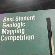
Best Student Geologic Map Competition at the Geological Society of America (GSA) Connects Annual Meeting
Each year, the USGS runs a poster session at the Geological Society of America (GSA) Connects Annual Meeting in which participants present their geologic mapping work. The top three student-authored geologic maps receive awards and recognition at a ceremony sponsored by GSA, GSA Foundation, Association of American State Geologists, American Institute of Professional Geologists, American...
GLGMC Science in Action
The testimonials below demonstrate the impact of recent geologic mapping projects carried out by the GLGMC.
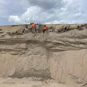
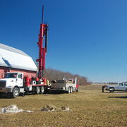
GLGMC Current Projects
These projects highlight the important research conducted through the GLGMC.
Great Lakes Geologic Mapping Coalition (GLGMC)
The Great Lakes Geologic Mapping Coalition (GLGMC) advances the understanding of the three-dimensional distribution of the glacial sediments that overlie the bedrock of the glaciated terrain of the Great Lakes Region. This region includes 8 U.S. States (Illinois, Indiana, Michigan, Minnesota, New York, Ohio, Pennsylvania, and Wisconsin) and the Canadian Province of Ontario.

STATEMAP
Through the STATEMAP component of the NCGMP, state partners are developing a national geologic framework driven by areas of economic, social, or scientific interest. STATEMAP mapping priorities are established by State Geological Surveys in consultation with a multi-representational State Mapping Advisory Committee. These priorities are based on multiple factors including a) state requirements for...

EDMAP
As the educational component of the National Cooperative Geologic Mapping Program (NCGMP), EDMAP partners with colleges and universities to train the next generation of geologic mappers. To receive information related to the EDMAP Program, click on the button below:
Science and Products
Best Student Geologic Map Competition at the Geological Society of America (GSA) Connects Annual Meeting
Each year, the USGS runs a poster session at the Geological Society of America (GSA) Connects Annual Meeting in which participants present their geologic mapping work. The top three student-authored geologic maps receive awards and recognition at a ceremony sponsored by GSA, GSA Foundation, Association of American State Geologists, American Institute of Professional Geologists, American...
GLGMC Science in Action
The testimonials below demonstrate the impact of recent geologic mapping projects carried out by the GLGMC.
GLGMC Current Projects
These projects highlight the important research conducted through the GLGMC.
Great Lakes Geologic Mapping Coalition (GLGMC)
The Great Lakes Geologic Mapping Coalition (GLGMC) advances the understanding of the three-dimensional distribution of the glacial sediments that overlie the bedrock of the glaciated terrain of the Great Lakes Region. This region includes 8 U.S. States (Illinois, Indiana, Michigan, Minnesota, New York, Ohio, Pennsylvania, and Wisconsin) and the Canadian Province of Ontario.
STATEMAP
Through the STATEMAP component of the NCGMP, state partners are developing a national geologic framework driven by areas of economic, social, or scientific interest. STATEMAP mapping priorities are established by State Geological Surveys in consultation with a multi-representational State Mapping Advisory Committee. These priorities are based on multiple factors including a) state requirements for...
EDMAP
As the educational component of the National Cooperative Geologic Mapping Program (NCGMP), EDMAP partners with colleges and universities to train the next generation of geologic mappers. To receive information related to the EDMAP Program, click on the button below: